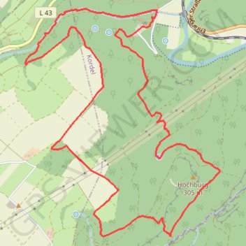
Premiumweg Römerpfad
Durch Wald und Flur führen schmale Pfade mit spektakulären Aussichten. Viele Spuren der römischen Vergangenheit liegen direkt am Weg. Mit dem abwechslungsreichen Relief, den Wasserfällen und den zahlreichen Sehenswürdigkeiten verläuft der Weg durch eines der schönsten Wandergebiete im Kreis Trier-Saarburg. Auf dem zehn km langen Rundweg zwischen Kordel und Butzweiler erlebt man die Burg Ramstein, die Genovevahöhle, keltische Ringwälle, Teile der römischen Langmauer und schließlich das römische Bergwerk „Pützlöcher“. Spannender kann eine Wanderung kaum sein!
- Distance: 6.0 mi
- Elevation gain: 1,427 ft
- Maximum elevation: 1,316 ft
- Elevation loss: 1,427 ft
- Minimum elevation: 476 ft
Interactive map
GPS track profile
About this GPS track
Name: Premiumweg Römerpfad GPS track, route, trail
Coordinates: 49.80588 6.62862 49.82499 6.65395
Other GPS tracks
Click on a GPS track to view route, its statistics and profile.
Rhin par la rive gauche
Suisse > Uri > Korporation Ursern > Andermatt
Vélo. En aller simple entre Andermatt et Hoek van Holland. Suisse centrale. #Vélo #SuisseCentrale #Alpes #Montagne #Nature
Distance: 903.8 mi • Elevation gain: 22,533 ft • Maximum elevation: 6,716 ft
Eurovelo 15 - Entire Route
Pays-Bas > Hollande-Méridionale > Hoek van Holland
Distance: 903.2 mi • Elevation gain: 27,156 ft • Maximum elevation: 6,716 ft
Tour d'Europe
France > Bretagne > Finistère > Concarneau > Landan Creis
Distance: 4,432.2 mi • Elevation gain: 146,335 ft • Maximum elevation: 7,982 ft
Rhin par la rive gauche
Suisse > Uri > Korporation Ursern > Andermatt
Distance: 903.6 mi • Elevation gain: 20,518 ft • Maximum elevation: 6,726 ft
Saint-Jacques-de-Compostelle - Trier - Metz
Allemagne > Rhénanie-Palatinat > Landkreis Trier-Saarburg > Newel
Distance: 76.6 mi • Elevation gain: 5,820 ft • Maximum elevation: 1,335 ft
RAF 2022 / 2600 n1 News
France > Hauts-de-France > Pas-de-Calais > Le Touquet-Paris-Plage
Distance: 1,612.3 mi • Elevation gain: 130,331 ft • Maximum elevation: 9,075 ft
Stage 14: Frederikshavn to Aars — European Divide Trail
Danemark > Jutland du Nord > Frederikshavn
Distance: 1,382.7 mi • Elevation gain: 94,114 ft • Maximum elevation: 4,557 ft
Eurovelo 15 - Strasbourg Rotterdam
France > Grand Est > Bas-Rhin > Strasbourg
comment ...
Distance: 554.1 mi • Elevation gain: 7,021 ft • Maximum elevation: 479 ft
Eurovéloroute-15-Route-du-Rhin
Suisse > Uri > Korporation Ursern > Andermatt
Distance: 931.4 mi • Elevation gain: 22,854 ft • Maximum elevation: 6,713 ft
Merlimont (62155), Pas-de-Calais, Hauts-de-France, France - Nice (06000-06300), Alpes-Maritimes, France
France > Hauts-de-France > Pas-de-Calais > Merlimont
Distance: 1,445.5 mi • Elevation gain: 38,990 ft • Maximum elevation: 1,719 ft
Eurovelo 15 - Entire Route
Pays-Bas > Hollande-Méridionale > Hoek van Holland
Distance: 903.5 mi • Elevation gain: 25,433 ft • Maximum elevation: 6,726 ft
Trace
France > Normandie > Seine-Maritime > Saint-Laurent-de-Brèvedent
Distance: 1,334.4 mi • Elevation gain: 77,890 ft • Maximum elevation: 5,308 ft
Megève - Ohain
France > Auvergne-Rhône-Alpes > Haute-Savoie > Megève
<p>De Route de Rochebrune, 74120 Megève, Auvergne-Rhône-Alpes, France<br/> À Chemin du Moulin, 1380 Ohain, Belgique</p> <p>Routage Moto - le plus joli</p>
Distance: 493.9 mi • Elevation gain: 29,961 ft • Maximum elevation: 4,452 ft
Itinéraire de Ham-sur-Heure-Nalinnes à Le Bonhomme
Belgique > Hainaut > Thuin > Ham-sur-Heure
Distance: 282.9 mi • Elevation gain: 14,616 ft • Maximum elevation: 3,127 ft
Marche-en-Famenne
Belgique > Luxembourg > Marche-en-Famenne > Marche-en-Famenne
<p>From Rue Dupont 46, 6900 Marche-en-Famenne, Belgium<br/> To Avenue de France, 6900 Marche-en-Famenne, Belgium</p> <p>Routing Motor - nicest</p>
Distance: 1,766.8 mi • Elevation gain: 94,672 ft • Maximum elevation: 3,537 ft
Eurovelo 15 - Strasbourg Rotterdam
France > Grand Est > Bas-Rhin > Strasbourg
Distance: 554.1 mi • Elevation gain: 6,903 ft • Maximum elevation: 479 ft
Eurovelo 15 - Entire Route
Pays-Bas > Hollande-Méridionale > Hoek van Holland
Distance: 903.5 mi • Elevation gain: 25,433 ft • Maximum elevation: 6,726 ft
Jour 19 / 28 Juin 2022 (Final)
Distance: 548.6 mi • Elevation gain: 26,273 ft • Maximum elevation: 3,123 ft
Riethoven naar Oostenrijk
Netherlands > North Brabant > Riethoven > Eind
Distance: 573.0 mi • Elevation gain: 44,715 ft • Maximum elevation: 6,224 ft
Vuisternens-devant-Romont à Bonn
Suisse > Fribourg > District de la Glâne > Sommentier > La Magne
Distance: 400.8 mi • Elevation gain: 24,304 ft • Maximum elevation: 3,802 ft
Premiumweg Römerpfad
Allemagne > Rhénanie-Palatinat > Landkreis Trier-Saarburg > Newel
Durch Wald und Flur führen schmale Pfade mit spektakul&auml;ren Aussichten. Viele Spuren der r&ouml;mischen Vergangenheit liegen direkt am Weg. Mit dem abwechslungsreichen Relief, den Wasserf&auml;llen und den zahlreichen Sehenswürdigkeiten verl&auml;uft der Weg durch eines der sch&ouml;nsten Wandergebiete im…
Distance: 6.0 mi • Elevation gain: 1,427 ft • Maximum elevation: 1,316 ft