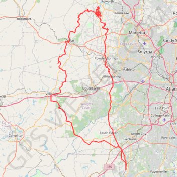
Powder Springs, Allatoona trails, Dallas, Chatt Hills
- Distance: 198.6 mi
- Elevation gain: 12,484 ft
- Maximum elevation: 1,243 ft
- Elevation loss: 12,484 ft
- Minimum elevation: 725 ft
- Moving time: 16 h 36 m
- Moving speed: 12.0 mph
- Maximum speed: 37.9 mph
- Total time: 17 h 59 m
- Global speed: 11.0 mph
- Date: 04/06/2024
Interactive map
GPS track profile
About this GPS track
Name: Powder Springs, Allatoona trails, Dallas, Chatt Hills GPS track, route, trail
Coordinates: 33.45285 -84.92358 34.04516 -84.59607
Topography: Fayette County topographic map
Other GPS tracks
Click on a GPS track to view route, its statistics and profile.