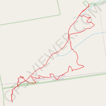
Lyon Mountain Loop
Loop hike to Lyon Mountain Fire Tower via Lyon Mountain Trail and Old Lyon Mountain Trail in the Chazy Highlands State Forest and the Adirondacks Park. #Hike #Loop #Mountain #Nature #Forest #Park
- Distance: 5.3 mi
- Elevation gain: 1,877 ft
- Maximum elevation: 3,793 ft
- Elevation loss: 1,880 ft
- Minimum elevation: 1,913 ft
- Moving time: 2 h 49 m
- Moving speed: 1.9 mph
- Maximum speed: 2.9 mph
- Total time: 2 h 54 m
- Global speed: 1.8 mph
- Date: 12/02/2021
Interactive map
GPS track profile
About this GPS track
Name: Lyon Mountain Loop GPS track, route, trail
Coordinates: 44.70476 -73.86292 44.72394 -73.84013
Topography: Clinton County topographic map
Other GPS tracks
Click on a GPS track to view route, its statistics and profile.
Montréal - New York
Canada > Québec > Agglomération de Montréal > Montréal
Distance: 396.0 mi • Elevation gain: 13,563 ft • Maximum elevation: 988 ft