Cleland Conservation Park - Mount Lofty
Interactive map
GPS track profile
About this GPS track
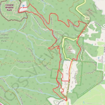
Name: Cleland Conservation Park - Mount Lofty GPS track, route, trail
End: Steub Trail, Cleland, Adelaide Hills Council, South Australia, 5152, Australia (-34.96640 138.69793)
Coordinates: -34.98482 138.69675 -34.96557 138.71318
Other GPS tracks
Click on a GPS track to view route, its statistics and profile.
Belair National Park - Mount Lofty
Australia > South Australia > Adelaide
#Bike
Distance: 8.1 mi • Elevation gain: 1,650 ft • Maximum elevation: 2,310 ft