22 Oct 2023
- Distance: 40.8 mi
- Elevation gain: 630 ft
- Maximum elevation: 282 ft
- Elevation loss: 627 ft
- Minimum elevation: -23 ft
Interactive map
GPS track profile
About this GPS track
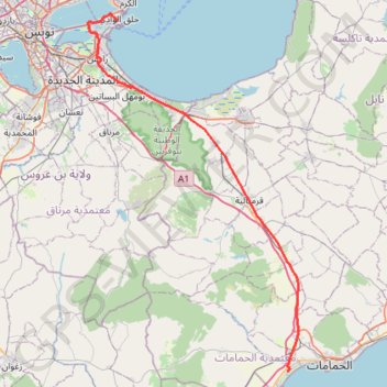
Name: 22 Oct 2023 GPS track, route, trail
Start: La Goulette, Délégation La Goulette, Tunis, Gouvernorat Tunis, 2060, Tunisie (36.81275 10.30241)
Coordinates: 36.39100 10.25955 36.82013 10.57335
Other GPS tracks
Click on a GPS track to view route, its statistics and profile.
Ride 2022-01-02
Tunisie > Gouvernorat Ben Arous > Hammem Lif Ville 2
Distance: 25.1 mi • Elevation gain: 3,789 ft • Maximum elevation: 1,184 ft