Mount Wilson
Hike to Mount Wilson from Sierra Madre via Mount Wilson Trail in Angeles National Forest. #Hike #Mountain #Nature #Forest #Angeles
- Distance: 7.1 mi
- Elevation gain: 5,597 ft
- Maximum elevation: 5,640 ft
- Elevation loss: 948 ft
- Minimum elevation: 988 ft
- Moving time: 1 h 7 m
- Moving speed: 6.3 mph
- Maximum speed: 10.2 mph
- Total time: 1 h 7 m
- Global speed: 6.3 mph
- Date: 12/31/2009
Interactive map
GPS track profile
About this GPS track
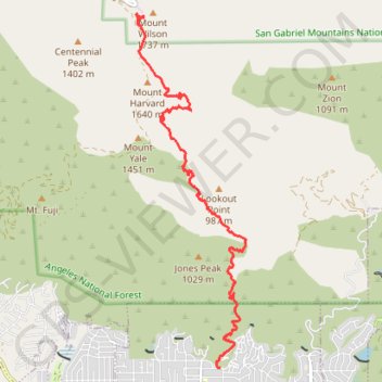
Name: Mount Wilson GPS track, route, trail
End: Rim Trail, Mount Wilson, Los Angeles County, California, 91023, United States (34.22312 -118.06266)
Coordinates: 34.16945 -118.06428 34.22358 -118.04380
Topography: Los Angeles County topographic map
Other GPS tracks
Click on a GPS track to view route, its statistics and profile.