Lolo Vista (Kauai Island)
Hike to Lolo Vista via Nu'alolo Trail in the Na Pali-Kona Forest Reserve and the Ku'ia Natural Area Reserve on the Kaua'i island. #Hike #Nature #Mountain #Volcano #Sea #Pacific #Ocean #Forest #Island #Hawaii
- Distance: 4.3 mi
- Elevation gain: 210 ft
- Maximum elevation: 3,780 ft
- Elevation loss: 2,142 ft
- Minimum elevation: 1,755 ft
- Moving time: 1 h 57 m
- Moving speed: 2.2 mph
- Maximum speed: 4.4 mph
- Total time: 1 h 59 m
- Global speed: 2.1 mph
- Date: 02/25/2024
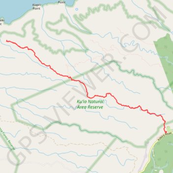
Interactive map
GPS track profile
About this GPS track
Name: Lolo Vista (Kauai Island) GPS track, route, trail
Start: Nu'alolo Trail, Kauaʻi County, Hawaii, United States (22.12977 -159.65986)
End: Kauaʻi County, Hawaii, United States (22.15338 -159.70439)
Coordinates: 22.12942 -159.70448 22.15338 -159.65970
Topography: Kauaʻi County topographic map
Other GPS tracks
Click on a GPS track to view route, its statistics and profile.
Lolo Vista and Nu'alolo Cliffs Loop (Kaua'i Island)
United States > Hawaii > Kauaʻi County
Loop hike to Lolo Vista and Nu'alolo Cliffs via Nu'alolo Trail, Nu'alolo Cliffs Trail, Awa'awapuhi Trail and Koke'e Road in the Koke'e State Park, Ku'ia Natural Area Reserve and Na Pali-Kona Forest Reserve. #Hike #Loop #Mountain #Volcano #Nature #Forest #Cliffs #Ocean #Sea #Pacific #Island #Hawaii #Island
Distance: 11.7 mi • Elevation gain: 3,166 ft • Maximum elevation: 4,098 ft