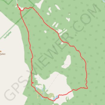
16-OCT-21 15:16:03
- Distance: 7.4 mi
- Elevation gain: 974 ft
- Maximum elevation: 2,930 ft
- Elevation loss: 942 ft
- Minimum elevation: 2,172 ft
- Moving time: 4 h 3 m
- Moving speed: 1.8 mph
- Maximum speed: 2.9 mph
- Total time: 5 h 38 m
- Global speed: 1.3 mph
- Date: 10/16/2021
Interactive map
GPS track profile
About this GPS track
Name: 16-OCT-21 15:16:03 GPS track, route, trail
Start: Nyvallen, Härjedalens kommun, Comté de Jämtland, Suède (62.31739 13.56442)
End: Nyvallen, Härjedalens kommun, Comté de Jämtland, Suède (62.31628 13.56477)
Coordinates: 62.28221 13.56424 62.31740 13.61896
Other GPS tracks
Click on a GPS track to view route, its statistics and profile.
Stage 1: Arctic Ocean to Väylä — European Divide Trail
Distance: 1,730.5 mi • Elevation gain: 78,159 ft • Maximum elevation: 2,369 ft
17-OCT-21 14:49:35
Distance: 5.8 mi • Elevation gain: 951 ft • Maximum elevation: 2,982 ft