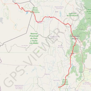
Paso-Cafayate
Vélo. En aller simple. #Vélo
- Distance: 451.1 mi
- Elevation gain: 21,969 ft
- Maximum elevation: 15,830 ft
- Elevation loss: 31,923 ft
- Minimum elevation: 3,488 ft
Interactive map
GPS track profile
About this GPS track
Name: Paso-Cafayate GPS track, route, trail
Start: Ruta 27 CH, San Pedro de Atacama, Provincia de El Loa, Antofagasta, Chili (-22.91701 -67.79646)
End: Camping Luz y Fuerza, Ruta Nacional 40, Cafayate, Salta, A4427AHB, Argentine (-26.08058 -65.97755)
Coordinates: -26.08058 -67.79646 -22.90277 -65.24679
Other GPS tracks
Click on a GPS track to view route, its statistics and profile.
Lascar - Itinéraire Sud
Chili > Antofagasta > Provincia de El Loa > San Pedro de Atacama
Randonnée en aller-retour depuis Mesadas Romeros. #Randonnée
Distance: 4.0 mi • Elevation gain: 2,448 ft • Maximum elevation: 18,314 ft