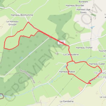
Trail 8,2 km
Trail 8,2 km
- Distance: 5.1 mi
- Elevation gain: 384 ft
- Maximum elevation: 348 ft
- Elevation loss: 387 ft
- Minimum elevation: 177 ft
Interactive map
GPS track profile
About this GPS track
Name: Trail 8,2 km GPS track, route, trail
Coordinates: 49.58920 -1.43314 49.60433 -1.39618
Other GPS tracks
Click on a GPS track to view its route, statistics and profile.
Tour d'Europe
France > Bretagne > Finistère > Concarneau > Landan Creis
Distance: 4,432.2 mi • Elevation gain: 146,335 ft • Maximum elevation: 7,982 ft
GR 223 Tour du Cotentin (2021)
France > Normandie > Eure > Berville-sur-Mer
Randonnée en Normandie sur le GR 223 autour du Cotentin à travers l'Eure, le Calvados et la Manche de Berville-sur-Mer au Mont-Saint-Michel.
Distance: 404.3 mi • Elevation gain: 21,932 ft • Maximum elevation: 489 ft
Sentier Cotentin - Cherbourg vers Mont-Saint-Michel
France > Normandie > Manche > La Hague > Urville-Nacqueville > La Rivière
Distance: 144.0 mi • Elevation gain: 8,478 ft • Maximum elevation: 420 ft
GR 223 : De Carentan à Cherbourg (Manche)
France > Normandie > Manche > Carentan-les-Marais
Randonnée en Normandie sur le GR 223, Le sentier du littoral, à travers la Manche de Carentan à Cherbourg via Brucheville, Sainte-Mère-Église, Tatihou (Saint-Vaast-la-Hougue), Saint-Vaast-la-Hougue et Saint-Pierre-Église. #Randonnée #GR223 #Mer #Campagne #Manche #Normandie #Cotentin #Nature
Distance: 79.9 mi • Elevation gain: 2,277 ft • Maximum elevation: 489 ft
Gravel bike
France > Normandie > Manche > Le Mesnil-au-Val > La Galle
Distance: 38.8 mi • Elevation gain: 2,385 ft • Maximum elevation: 486 ft
VTT 50 km
France > Normandie > Manche > Teurthéville-Bocage
VTT 50 km
Distance: 30.9 mi • Elevation gain: 2,326 ft • Maximum elevation: 505 ft
1ére étape 2024
France > Normandie > Manche > Cherbourg-en-Cotentin
6km allure contrôlée, 163km en course
Distance: 105.3 mi • Elevation gain: 7,139 ft • Maximum elevation: 505 ft
Carentan (50500), Carentan-les-Marais, Manche, Normandie, France - Caen (14000), Calvados, Normandie, France
France > Normandie > Manche > Carentan-les-Marais
Distance: 229.0 mi • Elevation gain: 11,299 ft • Maximum elevation: 863 ft
RAF 2022 / 2600 n1 News
France > Hauts-de-France > Pas-de-Calais > Le Touquet-Paris-Plage
Distance: 1,612.3 mi • Elevation gain: 130,331 ft • Maximum elevation: 9,075 ft
VTT 26 km
France > Normandie > Manche > Teurthéville-Bocage
VTT 26 km
Distance: 16.3 mi • Elevation gain: 1,253 ft • Maximum elevation: 410 ft
Trail 17 km
France > Normandie > Manche > Teurthéville-Bocage
Trail 17 km
Distance: 11.0 mi • Elevation gain: 1,079 ft • Maximum elevation: 404 ft
20635F01020013AD
France > Hauts-de-France > Pas-de-Calais > Berck
20635F01020013AD
Distance: 213.8 mi • Elevation gain: 10,299 ft • Maximum elevation: 1,122 ft
2 - VDSC VTT 55km
France > Normandie > Manche > Quettehou
VTT 55km
Distance: 35.6 mi • Elevation gain: 2,523 ft • Maximum elevation: 430 ft
20635F010200146B
France > Hauts-de-France > Pas-de-Calais > Berck
20635F010200146B
Distance: 250.1 mi • Elevation gain: 10,413 ft • Maximum elevation: 955 ft
Vendredi 31 mai
France > Normandie > Manche > Périers
Periers - Valognes - Periers
Distance: 79.7 mi • Elevation gain: 2,014 ft • Maximum elevation: 256 ft
Treport Mont saint Michel
France > Normandie > Seine-Maritime > Le Tréport
Vélo. En aller simple entre Le Tréport et Pontorson. #Vélo
Distance: 229.9 mi • Elevation gain: 11,132 ft • Maximum elevation: 938 ft
1 - Vélo 2024 - 100 km
France > Normandie > Manche > Martinvast > Les Rosées
Cyclisme sur routes départementales et communales
Distance: 62.1 mi • Elevation gain: 3,497 ft • Maximum elevation: 584 ft
Tous les coins du Cotentin-12150732
France > Normandie > Manche > Saint-Floxel
Distance: 197.5 mi • Elevation gain: 10,512 ft • Maximum elevation: 551 ft
2 - Vélo 2024 - 62.3 km
France > Normandie > Manche > Martinvast
Circuit vélo - 63 km
Distance: 38.6 mi • Elevation gain: 2,592 ft • Maximum elevation: 584 ft
Itinéraire de Nemours à Nemours
France > Centre-Val de Loire > Loiret > Bromeilles > Bainvilliers
Distance: 979.5 mi • Elevation gain: 28,005 ft • Maximum elevation: 781 ft
Randonnée Pédestre 8,88km
France > Normandie > Manche > Teurthéville-Bocage
Randonnée Pédestre 8,88km
Distance: 5.5 mi • Elevation gain: 367 ft • Maximum elevation: 312 ft
Randonnée Pédestre 15,58 km
France > Normandie > Manche > Teurthéville-Bocage
Randonnée Pédestre 15,58 km
Distance: 8.4 mi • Elevation gain: 620 ft • Maximum elevation: 344 ft
1 - etape-3-tdn-2024-parcours (1)
France > Normandie > Manche > Coutances
Etape 3 16 mars 2024
Distance: 85.2 mi • Elevation gain: 6,007 ft • Maximum elevation: 515 ft
GPX Download: Pour se rafraîchir 💦 – Champs et ruisseaux Circuit à partir de Digosville
France > Normandie > Manche > Cherbourg-en-Cotentin > Hameau des Champs
Distance: 35.4 mi • Elevation gain: 2,825 ft • Maximum elevation: 505 ft
Track-Saint de Luz retour
France > Nouvelle-Aquitaine > Pyrénées-Atlantiques > Saint-Jean-de-Luz
Distance: 704.3 mi • Elevation gain: 22,598 ft • Maximum elevation: 843 ft
Track-Saint Jean de Luz
Belgique > Hainaut > Ath > Lessines
Distance: 740.9 mi • Elevation gain: 31,145 ft • Maximum elevation: 1,594 ft
Lc100b-2022
France > Normandie > Manche > Bretteville > Hameau des Cordeliers
Distance: 64.1 mi • Elevation gain: 5,466 ft • Maximum elevation: 512 ft
Gravel bike
France > Normandie > Manche > Le Mesnil-au-Val > La Galle
Distance: 30.6 mi • Elevation gain: 1,998 ft • Maximum elevation: 486 ft
La_connerie_100_bornes
France > Normandie > Manche > Bretteville > Le Grand Heu
Distance: 63.6 mi • Elevation gain: 6,161 ft • Maximum elevation: 577 ft
RdA 2022 E3
France > Normandie > Manche > Le Havre de Quinéville > Les Roques
Distance: 64.3 mi • Elevation gain: 4,104 ft • Maximum elevation: 545 ft
Le chemin aux Anglais - Variante de Montebourg vers Cherbourg
France > Normandie > Manche > Cherbourg-en-Cotentin
Randonnée entre Cherbourg-Octeville et Montebourg. #Randonnée
Distance: 22.4 mi • Elevation gain: 1,670 ft • Maximum elevation: 587 ft
G2-G3 Dimanche D9
France > Normandie > Manche > Anneville-en-Saire
Distance: 41.0 mi • Elevation gain: 1,880 ft • Maximum elevation: 417 ft
G2-G3 Dimanche D6
France > Normandie > Manche > Anneville-en-Saire
Distance: 42.1 mi • Elevation gain: 1,768 ft • Maximum elevation: 364 ft
G2-G3 Dimanche D8
France > Normandie > Manche > Quettehou
Distance: 43.7 mi • Elevation gain: 1,535 ft • Maximum elevation: 308 ft