MacRitchie Reservoir and TreeTop Walk Loop
- Distance: 7.6 mi
- Elevation gain: 679 ft
- Maximum elevation: 292 ft
- Elevation loss: 679 ft
- Minimum elevation: 33 ft
Interactive map
GPS track profile
About this GPS track
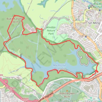
Name: MacRitchie Reservoir and TreeTop Walk Loop GPS track, route, trail
Coordinates: 1.33834 103.80595 1.36141 103.83653
Topography: Singapore topographic map
Other GPS tracks
Click on a GPS track to view route, its statistics and profile.
The Green Corridor - Singapore
Singapore > Northwest > Singapore
#Hike
Distance: 13.8 mi • Elevation gain: 548 ft • Maximum elevation: 144 ft
Bukit Timah Hill - MacRitchie Reservoir
Singapore > Southwest > Singapore
#Hike
Distance: 9.2 mi • Elevation gain: 951 ft • Maximum elevation: 548 ft
Directions from Duck Tour Ramp to Marina Boulevard, Singapore
Singapore > Central > Singapore
Distance: 65.5 mi • Elevation gain: 2,664 ft • Maximum elevation: 167 ft
Kualanamu International Airport to Jakarta, Indonesia
Indonésie > Sumatra du Nord > Deli Serdang > Beringin
Distance: 1,124.2 mi • Elevation gain: 36,014 ft • Maximum elevation: 410 ft