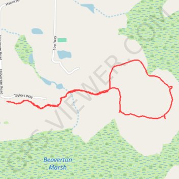
Beaverton Marsh Loop (San Juan Island)
Loop hike via Nuthatch Trail and Dragonfly Loop Trail in the Beaverton Marsh on the San Juan Island. #Hike #Loop #Nature #Forest
- Distance: 2.1 mi
- Elevation gain: 236 ft
- Maximum elevation: 187 ft
- Elevation loss: 236 ft
- Minimum elevation: 112 ft
- Moving time: 1 h 2 m
- Moving speed: 2.1 mph
- Maximum speed: 3.3 mph
- Total time: 1 h 3 m
- Global speed: 2.0 mph
- Date: 03/19/2024
Interactive map
GPS track profile
About this GPS track
Name: Beaverton Marsh Loop (San Juan Island) GPS track, route, trail
Start: 266, Taylors Way, San Juan County, Washington, 98250, United States (48.54633 -123.05506)
End: 262, Taylors Way, San Juan County, Washington, 98250, United States (48.54634 -123.05499)
Coordinates: 48.54517 -123.05506 48.54908 -123.03834
Topography: San Juan County topographic map
Other GPS tracks
Click on a GPS track to view route, its statistics and profile.