Açores, Faial: Levada
- Distance: 8.9 mi
- Elevation gain: 2,329 ft
- Maximum elevation: 3,271 ft
- Elevation loss: 2,323 ft
- Minimum elevation: 2,060 ft
Interactive map
GPS track profile
About this GPS track
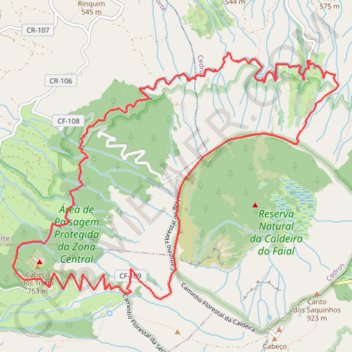
Name: Açores, Faial: Levada GPS track, route, trail
Start: Caminho Florestal da Canada Larga, Cedros, Horta, Açores, 9900-343, Portugal (38.60208 -28.70953)
End: Caminho Florestal da Canada Larga, Cedros, Horta, Açores, 9900-343, Portugal (38.60207 -28.70936)
Coordinates: 38.57893 -28.74603 38.60278 -28.70572
Other GPS tracks
Click on a GPS track to view route, its statistics and profile.
Faial Caldeira circle trail
Distance: 4.3 mi • Elevation gain: 1,056 ft • Maximum elevation: 3,346 ft
Trail Planner Map
Distance: 1.9 mi • Elevation gain: 1,138 ft • Maximum elevation: 2,956 ft
Praia do Norte
Randonnée pédestre. En aller simple. #Randonnée
Distance: 6.3 mi • Elevation gain: 440 ft • Maximum elevation: 3,031 ft