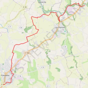
De Plabennec au Folgoët
Randonnée entre Plabennec et Ploudaniel. #Randonnée
- Distance: 8.5 mi
- Elevation gain: 381 ft
- Maximum elevation: 292 ft
- Elevation loss: 449 ft
- Minimum elevation: 108 ft
Interactive map
GPS track profile
About this GPS track
Name: De Plabennec au Folgoët GPS track, route, trail
Coordinates: 48.49575 -4.42890 48.55104 -4.34528
Other GPS tracks
Click on a GPS track to view route, its statistics and profile.
Tro Breizh 2021
France > Bretagne > Côtes-d'Armor > Merdrignac > Les Rues d'à Bas
Tro breizh 2021
Distance: 792.8 mi • Elevation gain: 67,552 ft • Maximum elevation: 1,027 ft
Stations vertes de bretagne
France > Bretagne > Ille-et-Vilaine > Combourg > Le Vieux Châtel
Vélo. En aller simple entre La Chapelle-aux-Filtzméens et Combourg. #Vélo
Distance: 551.6 mi • Elevation gain: 27,402 ft • Maximum elevation: 1,086 ft
Sentier des douaniers
France > Normandie > Manche > Le Mont-Saint-Michel
Distance: 1,210.5 mi • Elevation gain: 92,792 ft • Maximum elevation: 397 ft
Gr34 t1
France > Normandie > Manche > Le Mont-Saint-Michel
Distance: 1,198.8 mi • Elevation gain: 88,606 ft • Maximum elevation: 417 ft
Sentier des douaniers
France > Pays de la Loire > Loire-Atlantique > Saint-Nazaire
Distance: 1,210.4 mi • Elevation gain: 92,608 ft • Maximum elevation: 397 ft
De Le Drennec à Lannilis le long de l'Aber Wrac'h
France > Bretagne > Finistère > Le Drennec > Le Stang
Randonnée entre Le Drennec et Lannilis. #Randonnée
Distance: 12.1 mi • Elevation gain: 1,309 ft • Maximum elevation: 223 ft
150 bornes-16262521
France > Bretagne > Finistère > Brest
Distance: 93.1 mi • Elevation gain: 4,931 ft • Maximum elevation: 420 ft
Balade du 2021-08-25
France > Bretagne > Finistère > Plounéour-Brignogan-Plages > Kervenven
Distance: 102.3 mi • Elevation gain: 5,709 ft • Maximum elevation: 322 ft
TY ZEF 90 KMS TERRE-TERRE
France > Bretagne > Finistère > Brest
Distance: 55.0 mi • Elevation gain: 3,297 ft • Maximum elevation: 633 ft