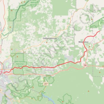
Railway Reserves Heritage Trail
- Distance: 26.7 mi
- Elevation gain: 1,280 ft
- Maximum elevation: 1,060 ft
- Elevation loss: 522 ft
- Minimum elevation: 89 ft
Interactive map
GPS track profile
About this GPS track
Name: Railway Reserves Heritage Trail GPS track, route, trail
End: Kep Track, Wundowie, Shire Of Northam, Western Australia, 6560, Australia (-31.77151 116.37228)
Coordinates: -31.89677 116.03584 -31.77151 116.37228
Other GPS tracks
Click on a GPS track to view route, its statistics and profile.
Lake Leshenaultia Loop
Australia > Western Australia > Chidlow
Leshenaultia Conservation Park. #Hike #MTB #Loop #Leshenaultia
Distance: 3.4 mi • Elevation gain: 299 ft • Maximum elevation: 1,043 ft
Swan View Tunnel and Falls
John Forrest National Park. #Hike #Loop #JohnForrest
Distance: 3.6 mi • Elevation gain: 335 ft • Maximum elevation: 486 ft
Kep Track - Northam
#MTB
Distance: 49.0 mi • Elevation gain: 2,178 ft • Maximum elevation: 1,079 ft
Perth to Sydney
Australie > Australie occidentale > City of Belmont
Distance: 2,362.0 mi • Elevation gain: 47,762 ft • Maximum elevation: 3,802 ft
2021 Toodyay return via Kep
Distance: 142.9 mi • Elevation gain: 6,099 ft • Maximum elevation: 1,171 ft
Red Hill - Eagle View Track
Australie > Australie occidentale
John Forrest National Park. #Hike #Loop #RedHill #JohnForrest
Distance: 15.0 mi • Elevation gain: 1,526 ft • Maximum elevation: 883 ft
Railway Reserves Heritage North Trail and Eagle View Track
Distance: 10.1 mi • Elevation gain: 1,178 ft • Maximum elevation: 778 ft
Kep 75k
Distance: 47.6 mi • Elevation gain: 2,949 ft • Maximum elevation: 1,017 ft
Kep 100k
Distance: 64.7 mi • Elevation gain: 3,392 ft • Maximum elevation: 1,056 ft