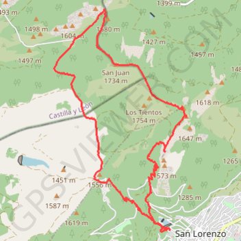
Monte Abantos, San Lorenzo del Escorial
Randonnée en boucle depuis San Lorenzo de El Escorial. #Randonnée #Boucle
- Distance: 10.1 mi
- Elevation gain: 2,661 ft
- Maximum elevation: 5,755 ft
- Elevation loss: 2,661 ft
- Minimum elevation: 3,622 ft
- Moving time: 3 h 59 m
- Moving speed: 2.5 mph
- Maximum speed: 4.0 mph
- Total time: 5 h 8 m
- Global speed: 2.0 mph
- Date: 11/20/2014
Interactive map
GPS track profile
About this GPS track
Name: Monte Abantos, San Lorenzo del Escorial GPS track, route, trail
Coordinates: 40.59411 -4.18401 40.63660 -4.15069
Other GPS tracks
Click on a GPS track to view route, its statistics and profile.
Eurovelo 01 Spain + Portugal
France > Nouvelle-Aquitaine > Pyrénées-Atlantiques > Hendaye
Distance: 1,930.7 mi • Elevation gain: 100,367 ft • Maximum elevation: 4,931 ft
EuroVelo 1 (Spain)
Espagne > Andalousie > Côte occidentale > Ayamonte
Distance: 842.4 mi • Elevation gain: 47,858 ft • Maximum elevation: 4,331 ft
Southern section — European Divide Trail
France > Auvergne-Rhône-Alpes > Drôme > Valence
Distance: 1,506.1 mi • Elevation gain: 139,026 ft • Maximum elevation: 6,578 ft
1 LUCENA - MONTPELLIER
Distance: 1,842.0 mi • Elevation gain: 96,785 ft • Maximum elevation: 3,438 ft
1 LUCENA - MONTPELLIER
Espagne > Andalousie > Lucena
Distance: 1,842.0 mi • Elevation gain: 96,785 ft • Maximum elevation: 3,438 ft
Stage 26: Valence to Saint-Jean-de-Fos — European Divide Trail
France > Auvergne-Rhône-Alpes > Drôme > Valence
Distance: 1,506.1 mi • Elevation gain: 139,026 ft • Maximum elevation: 6,578 ft
EuroVelo 1 (Spain)
Espagne > Andalousie > Côte occidentale > Ayamonte > Pozo del Camino > Fotea
Distance: 838.7 mi • Elevation gain: 44,754 ft • Maximum elevation: 4,331 ft