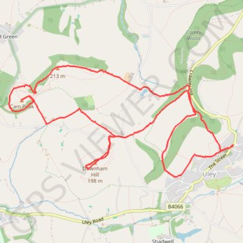
Walk through Uley, Cam Peak, and Downham Hill
- Distance: 6.2 mi
- Elevation gain: 1,342 ft
- Maximum elevation: 758 ft
- Elevation loss: 1,342 ft
- Minimum elevation: 341 ft
- Moving time: 2 h 45 m
- Moving speed: 2.3 mph
- Maximum speed: 5.5 mph
- Total time: 3 h 36 m
- Global speed: 1.7 mph
- Date: 05/05/2024
Interactive map
GPS track profile
About this GPS track
Name: Walk through Uley, Cam Peak, and Downham Hill GPS track, route, trail
Start: The Green, Uley, Stroud, Gloucestershire, England, GL11 5SN, United Kingdom (51.68610 -2.30212)
End: The Green, Uley, Stroud, Gloucestershire, England, GL11 5SN, United Kingdom (51.68603 -2.30234)
Coordinates: 51.68284 -2.33925 51.69422 -2.30212
Other GPS tracks
Click on a GPS track to view route, its statistics and profile.
Cam Peak
United Kingdom > England > Gloucestershire > Stroud > Nympsfield
Distance: 8.1 mi • Elevation gain: 1,312 ft • Maximum elevation: 794 ft
Dean2023-311
United Kingdom > England > Oxfordshire > Oxford
Distance: 192.8 mi • Elevation gain: 11,043 ft • Maximum elevation: 951 ft