Marathon - White River
- Distance: 56.0 mi
- Elevation gain: 2,464 ft
- Maximum elevation: 1,335 ft
- Elevation loss: 2,008 ft
- Minimum elevation: 620 ft
Interactive map
GPS track profile
About this GPS track
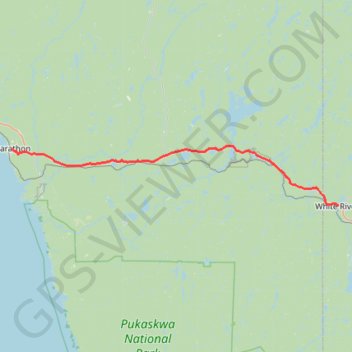
Name: Marathon - White River GPS track, route, trail
Coordinates: 48.59451 -86.36501 48.72462 -85.27878
Other GPS tracks
Click on a GPS track to view route, its statistics and profile.
Terrace Bay - Marathon
Canada > Ontario > Thunder Bay District > Terrace Bay Township
Lake Superior. #Bike #TerraceBay #Marathon #LakeSuperior
Distance: 51.6 mi • Elevation gain: 3,547 ft • Maximum elevation: 1,056 ft