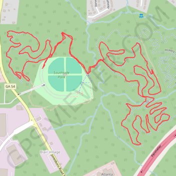
Southside Park MTB Loop
Mountain bike loop in Southside Park. #MTB #Loop #Forest #River #Nature
- Distance: 4.8 mi
- Elevation gain: 279 ft
- Maximum elevation: 912 ft
- Elevation loss: 279 ft
- Minimum elevation: 827 ft
- Moving time: 59 m 30 s
- Moving speed: 4.9 mph
- Maximum speed: 15.1 mph
- Total time: 59 m 30 s
- Global speed: 4.9 mph
- Date: 08/26/2021
Interactive map
GPS track profile
About this GPS track
Name: Southside Park MTB Loop GPS track, route, trail
Coordinates: 33.65800 -84.37322 33.66460 -84.36189
Topography: Atlanta topographic map