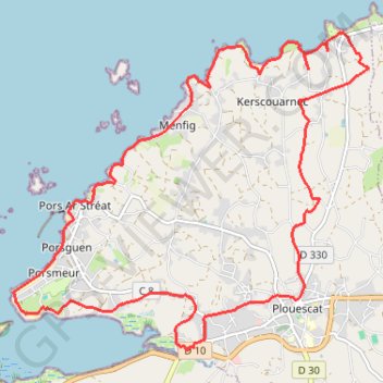
Import a GPX file

Autour de Plouescat

Randonnée en boucle depuis Plouescat. #Randonnée #Boucle

  • Distance: 11.0 mi
  • Elevation gain: 449 ft
  • Maximum elevation: 108 ft
  • Elevation loss: 449 ft
  • Minimum elevation: 0 ft
  • Moving time: 4 h 3 m
  • Moving speed: 2.7 mph
  • Maximum speed: 5.6 mph
  • Total time: 4 h 28 m
  • Global speed: 2.5 mph
  • Date: 02/19/2007

Interactive map

GPS track profile

About this GPS track

Other GPS tracks

Click on a GPS track to view route, its statistics and profile.

Sentier des douaniers

France > Normandie > Manche > Le Mont-Saint-Michel

Randonnée le long de la côte bretonne entre le Mont Saint-Michel et Saint-Nazaire. #Randonnée #Bretagne #Mer #Manche #Océan #Atlantique #Nature #GR34

Distance: 1,212.4 mi • Elevation gain: 93,540 ft • Maximum elevation: 417 ft

Tro Breizh 2021

France > Bretagne > Côtes-d'Armor > Merdrignac > Les Rues d'à Bas

Tro breizh 2021

Distance: 792.8 mi • Elevation gain: 67,552 ft • Maximum elevation: 1,027 ft

Sentier côtier entre Santec et Brouennou

France > Bretagne > Finistère > Santec > Méchou Rouz

Randonnée en bord de Manche sur le sentier des douaniers de Santec à Brouennou. #Randonnée #Bretagne #Manche #Mer #Nature #Campagne #GR34

Distance: 74.4 mi • Elevation gain: 3,789 ft • Maximum elevation: 187 ft

Littoral Bretagne

France > Bretagne > Ille-et-Vilaine > Vitré > Hospice St Nicolas

Randonnée le long des côtes bretonnes. #Randonnée #Bretagne #Nature #Mer #Manche #Océan #Atlantique #GR34

Distance: 994.7 mi • Elevation gain: 32,461 ft • Maximum elevation: 610 ft

8-De-Morlaix-à-Guissény

France > Bretagne > Finistère > Morlaix

Distance: 84.2 mi • Elevation gain: 5,203 ft • Maximum elevation: 285 ft

De Kerfissien à Languien

France > Bretagne > Finistère > Kerscouarnec > Poulfoën

Randonnée en boucle depuis Plouescat. #Randonnée #Boucle

Distance: 7.6 mi • Elevation gain: 233 ft • Maximum elevation: 98 ft

GR34 de Port Neuf à Goulven

France > Bretagne > Finistère > Moguériec > Keraval

Randonnée entre Sibiril et Goulven. #Randonnée

Distance: 17.2 mi • Elevation gain: 597 ft • Maximum elevation: 46 ft

Sentier des douaniers

France > Normandie > Manche > Le Mont-Saint-Michel

Distance: 1,210.5 mi • Elevation gain: 92,792 ft • Maximum elevation: 397 ft

Gr34 t1

France > Normandie > Manche > Le Mont-Saint-Michel

Distance: 1,198.8 mi • Elevation gain: 88,606 ft • Maximum elevation: 417 ft

Sentier des douaniers

France > Pays de la Loire > Loire-Atlantique > Saint-Nazaire

Distance: 1,210.4 mi • Elevation gain: 92,608 ft • Maximum elevation: 397 ft

Roscoff - Goulven

France > Bretagne > Finistère > Roscoff > Le Raz

Vélo. En aller simple entre Roscoff et Goulven. #Vélo #Bretagne #Manche #Mer

Distance: 27.1 mi • Elevation gain: 1,093 ft • Maximum elevation: 135 ft

Boucle de Kerzéan-16435163

France > Bretagne > Finistère > Plouescat

Distance: 4.5 mi • Elevation gain: 331 ft • Maximum elevation: 151 ft

GR34 De Santec (Finistère) à Brouennou (Meuse)

France > Bretagne > Finistère > Santec > Méchou Rouz

Randonnée entre Santec et Landéda. #Randonnée

Distance: 74.1 mi • Elevation gain: 3,635 ft • Maximum elevation: 184 ft

De Kerfissien au château de Traonjoly

France > Bretagne > Finistère > Cléder > Téven Meur

Randonnée en boucle depuis Cléder. #Randonnée #Boucle

Distance: 9.0 mi • Elevation gain: 381 ft • Maximum elevation: 128 ft

150 bornes-16262521

France > Bretagne > Finistère > Brest

Distance: 93.1 mi • Elevation gain: 4,931 ft • Maximum elevation: 420 ft

Roscoff / Goulven

France > Bretagne > Finistère > Roscoff > Keradraon

Distance: 27.6 mi • Elevation gain: 1,102 ft • Maximum elevation: 135 ft