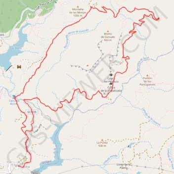
Trail Planner Map
- Distance: 7.4 mi
- Elevation gain: 2,415 ft
- Maximum elevation: 3,163 ft
- Elevation loss: 2,415 ft
- Minimum elevation: 2,054 ft
Interactive map
GPS track profile
About this GPS track
Name: Trail Planner Map GPS track, route, trail
Start: Lugar Soria, Soria, Mogán, Las Palmas, Îles Canaries, Espagne (27.90659 -15.66989)
End: Lugar Soria, Soria, Mogán, Las Palmas, Îles Canaries, Espagne (27.90659 -15.66985)
Coordinates: 27.90633 -15.67051 27.92941 -15.64712
Other GPS tracks
Click on a GPS track to view route, its statistics and profile.
TGCC 2024 10.07.2023
Espagne > Las Palmas de Grande Canarie
Distance: 79.6 mi • Elevation gain: 23,612 ft • Maximum elevation: 5,728 ft