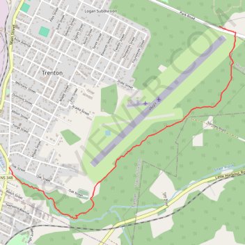
Trenton Park - Airport Route
Purple Route
- Distance: 2.2 mi
- Elevation gain: 121 ft
- Maximum elevation: 328 ft
- Elevation loss: 308 ft
- Minimum elevation: 26 ft
- Moving time: 50 m 18 s
- Moving speed: 2.6 mph
- Maximum speed: 3.6 mph
- Total time: 52 m 28 s
- Global speed: 2.5 mph
- Date: 05/01/2024
Interactive map
GPS track profile
About this GPS track
Name: Trenton Park - Airport Route GPS track, route, trail
End: 34, Main Street, Town of Trenton, Pictou County, Nova Scotia, B2H 1Y3, Canada (45.60646 -62.63797)
Coordinates: 45.60246 -62.63797 45.61766 -62.61233
Other GPS tracks
Click on a GPS track to view route, its statistics and profile.
Pictou - Antigonish
Canada > Nova Scotia > Town of Pictou > Pictou
Gulf of Saint Lawrence. #Bike #Pictou #Antigonish #SaintLawrence #Atlantic
Distance: 63.3 mi • Elevation gain: 2,651 ft • Maximum elevation: 482 ft
Pictou - Antigonish
Canada > Nova Scotia > Town of Pictou > Pictou
#Bike #Pictou #Antigonish
Distance: 46.2 mi • Elevation gain: 2,441 ft • Maximum elevation: 505 ft