Gorges d'Imbros
De Imbros à Chora Sfakion. #Randonnée
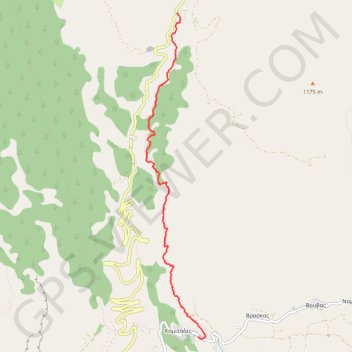
- Distance: 3.8 mi
- Elevation gain: 404 ft
- Maximum elevation: 2,513 ft
- Elevation loss: 2,349 ft
- Minimum elevation: 545 ft
Interactive map
GPS track profile
About this GPS track
Name: Gorges d'Imbros GPS track, route, trail
Coordinates: 35.20744 24.16290 35.24799 24.17194
Other GPS tracks
Click on a GPS track to view route, its statistics and profile.
Trail Planner Map
Grèce > Région Crète > Περιφερειακή Ενότητα Χανίων > Imbros
Distance: 3.9 mi • Elevation gain: 249 ft • Maximum elevation: 2,497 ft