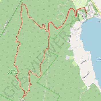
Elmore Mountain Loop
Loop hike from Lake Elmore to Elmore Mountain via Ridge Trail and Fire Tower Trail in the Elmore State Park. #Hike #Loop #Mountain #Nature #Lake #Forest #Park
- Distance: 5.6 mi
- Elevation gain: 1,512 ft
- Maximum elevation: 2,572 ft
- Elevation loss: 1,512 ft
- Minimum elevation: 1,158 ft
- Moving time: 2 h 14 m
- Moving speed: 2.5 mph
- Maximum speed: 4.0 mph
- Total time: 2 h 31 m
- Global speed: 2.2 mph
- Date: 11/01/2022
Interactive map
GPS track profile
About this GPS track
Name: Elmore Mountain Loop GPS track, route, trail
Start: Beach Road, Lake Elmore, Elmore, Lamoille County, Vermont, 05657, United States (44.54239 -72.52895)
End: Beach Road, Lake Elmore, Elmore, Lamoille County, Vermont, 05657, United States (44.54241 -72.52903)
Coordinates: 44.52639 -72.54859 44.54422 -72.52895
Topography: Elmore topographic map
Other GPS tracks
Click on a GPS track to view route, its statistics and profile.