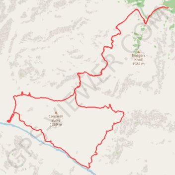
Cogswell Butte Loop (Grand Canyon)
Loop hike from Bill Hall Trailhead around Cogswell Butte via Bill Hall Trail, Thunder River Trail, Thunder River Falls, Tapeats Creek Trail, Colorado River, Deer Creek Trail, Deer Creek Falls and Deer Spring in the Grand Canyon National Park. #Hike #Loop #Canyon #Mountain #River #Falls #Nature #Park
- Distance: 28.3 mi
- Elevation gain: 11,358 ft
- Maximum elevation: 7,211 ft
- Elevation loss: 11,358 ft
- Minimum elevation: 1,952 ft
Interactive map
GPS track profile
About this GPS track
Name: Cogswell Butte Loop (Grand Canyon) GPS track, route, trail
Start: NF-292A, Coconino County, Arizona, United States (36.43478 -112.42981)
End: NF-292A, Coconino County, Arizona, United States (36.43478 -112.42979)
Coordinates: 36.37077 -112.50982 36.43507 -112.42979
Topography: Coconino County topographic map