Route
- Distance: 0.7 mi
- Elevation gain: 180 ft
- Maximum elevation: 2,746 ft
- Elevation loss: 180 ft
- Minimum elevation: 2,608 ft
Interactive map
GPS track profile
About this GPS track
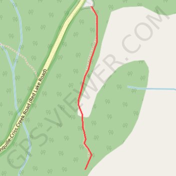
Name: Route GPS track, route, trail
Coordinates: 50.75051 -120.52438 50.75503 -120.52356
Other GPS tracks
Click on a GPS track to view route, its statistics and profile.
Cache Creek - Kamloops
Canada > British Columbia > Thompson-Nicola Regional District > Cache Creek
Distance: 54.0 mi • Elevation gain: 3,655 ft • Maximum elevation: 2,415 ft