Littleton Gravel/Unpaved Cycling
- Distance: 35.5 mi
- Elevation gain: 1,027 ft
- Maximum elevation: 5,610 ft
- Elevation loss: 1,027 ft
- Minimum elevation: 5,295 ft
- Moving time: 2 h 27 m
- Moving speed: 14.5 mph
- Maximum speed: 29.5 mph
- Total time: 2 h 28 m
- Global speed: 14.4 mph
- Date: 05/11/2024
Interactive map
GPS track profile
About this GPS track
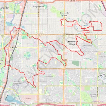
Name: Littleton Gravel/Unpaved Cycling GPS track, route, trail
Coordinates: 39.57935 -105.02613 39.63779 -104.91802
Topography: Arapahoe County topographic map
Other GPS tracks
Click on a GPS track to view route, its statistics and profile.
Douglas County Gravel/Unpaved Cycling
United States > Colorado > Douglas County
Gravel cycling route
Distance: 45.6 mi • Elevation gain: 2,388 ft • Maximum elevation: 6,309 ft
Waterton Canyon
United States > Colorado > Arapahoe County > Littleton
Distance: 35.7 mi • Elevation gain: 2,454 ft • Maximum elevation: 6,017 ft