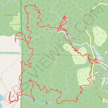
Grant Grove Village to Sequoia Lake Loop
Loop hike from Grant Grove Village to Sequoia Lake via Sunset Trail, Ella Falls, Dead Giant Loop Trail, Sequoia Lake Overlook, North Grove Trail, Centennial Stump, General Grant Tree, Tennessee Tree, Michigan Tree and South Boundary Trail in the Kings Canyon National Park and the Giant Sequoia National Forest. #Hike #Loop #Nature #Forest #Falls #Lake #Mountain #Park
- Distance: 10.9 mi
- Elevation gain: 2,110 ft
- Maximum elevation: 6,637 ft
- Elevation loss: 2,110 ft
- Minimum elevation: 5,400 ft
Interactive map
GPS track profile
About this GPS track
Name: Grant Grove Village to Sequoia Lake Loop GPS track, route, trail
Coordinates: 36.73136 -118.98580 36.75201 -118.96244
Topography: Tulare County topographic map
Other GPS tracks
Click on a GPS track to view route, its statistics and profile.
JMT1-16847633
États-Unis d'Amérique > Californie > Inyo County
Distance: 249.4 mi • Elevation gain: 49,836 ft • Maximum elevation: 14,386 ft