Exeter Walking
Interactive map
GPS track profile
About this GPS track
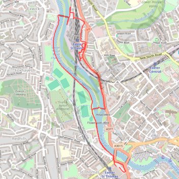
Name: Exeter Walking GPS track, route, trail
Start: Alphington Street, St Thomas, Exeter, Devon, England, EX2 8AF, United Kingdom (50.71732 -3.53743)
End: Alphington Street, St Thomas, Exeter, Devon, England, EX2 8AF, United Kingdom (50.71739 -3.53784)
Coordinates: 50.71685 -3.54717 50.73235 -3.53648
Other GPS tracks
Click on a GPS track to view route, its statistics and profile.
Tour d'Europe
France > Bretagne > Finistère > Concarneau > Landan Creis
Distance: 4,432.2 mi • Elevation gain: 146,335 ft • Maximum elevation: 7,982 ft
Tour de la petite Manche Angleterre
Royaume-Uni > Angleterre > Plymouth
Vélo. En aller simple entre Plymouth et Weymouth. #Vélo
Distance: 170.2 mi • Elevation gain: 13,432 ft • Maximum elevation: 974 ft
TT22 Jo11 J9/06 : Cheddar à Plymouth Ferry Terminal
Royaume-Uni > Angleterre > Somerset > Cheddar
Distance: 166.7 mi • Elevation gain: 13,681 ft • Maximum elevation: 1,503 ft