Cap-Vert_J2_2015-03-30
6 jours de randonnée sur l\'île de Santo Antao du Cap Vert
- Distance: 5.6 mi
- Elevation gain: 1,302 ft
- Maximum elevation: 4,242 ft
- Elevation loss: 4,747 ft
- Minimum elevation: 761 ft
- Moving time: 2 h 33 m
- Moving speed: 2.2 mph
- Maximum speed: 6.0 mph
- Total time: 4 h 33 m
- Global speed: 1.2 mph
- Date: 03/30/2015
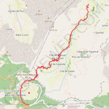
Interactive map
GPS track profile
About this GPS track
Name: Cap-Vert_J2_2015-03-30 GPS track, route, trail
Start: Porto Novo, 1310, Cap-Vert (17.10348 -25.06264)
End: Junta, Lombinho, Paul, 1210, Cap-Vert (17.13855 -25.04111)
Coordinates: 17.10347 -25.06579 17.13855 -25.04111
Other GPS tracks
Click on a GPS track to view route, its statistics and profile.
N_3_
Cap-Vert > Ribeira Grande > Ribeira Grande > Varzinha
Distance: 4.0 mi • Elevation gain: 4,423 ft • Maximum elevation: 4,757 ft
Cap vert - Vallée de Paul - Boca de Figueiras - Paul
Cap-Vert > Paul > Chã de Fazenda
Randonnée pédestre. Entre Faja de Cima et Paul. #Randonnée
Distance: 7.0 mi • Elevation gain: 1,506 ft • Maximum elevation: 2,208 ft
Patrice_FIVEL_2024-03-11_08-00-07
Cap-Vert > São Vicente > Mindelo
Distance: 24.6 mi • Elevation gain: 5,253 ft • Maximum elevation: 4,744 ft
5_bis_11km_fini
Cap-Vert > Porto Novo > Agua das Caldeiras > Água das Caldeiras
Distance: 7.3 mi • Elevation gain: 1,755 ft • Maximum elevation: 4,239 ft
18.03 - Cova - Vila das Pombas - 13.5 km
Cap-Vert > Porto Novo > Agua das Caldeiras > Água das Caldeiras
Descente sur Paul par la 101 puis bifurcation sur la 102 via le Pico d'Antonio
Distance: 8.6 mi • Elevation gain: 1,558 ft • Maximum elevation: 4,236 ft
N5_
Cap-Vert > Ribeira Grande > Espongeiro > Água das Caldeiras
Distance: 3.3 mi • Elevation gain: 1,033 ft • Maximum elevation: 4,757 ft
N_3_fini
Cap-Vert > Ribeira Grande > Espongeiro > Água das Caldeiras
Distance: 4.7 mi • Elevation gain: 1,562 ft • Maximum elevation: 4,757 ft
N5_10km
Cap-Vert > Porto Novo > Agua das Caldeiras > Água das Caldeiras
Distance: 6.9 mi • Elevation gain: 1,503 ft • Maximum elevation: 4,239 ft
20151011
Cap-Vert > Porto Novo > Porto Novo
Distance: 11.5 mi • Elevation gain: 5,417 ft • Maximum elevation: 4,869 ft