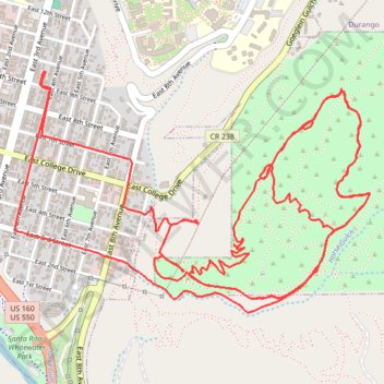
First time riding Medicine 🤘 thought it would be harder? 🤷♂️
- Distance: 8.7 mi
- Elevation gain: 1,463 ft
- Maximum elevation: 7,244 ft
- Elevation loss: 1,463 ft
- Minimum elevation: 6,535 ft
- Moving time: 1 h 20 m
- Moving speed: 6.5 mph
- Maximum speed: 28.2 mph
- Total time: 2 h 32 m
- Global speed: 3.4 mph
- Date: 06/06/2024
Interactive map
GPS track profile
About this GPS track
Name: First time riding Medicine 🤘 thought it would be harder? 🤷♂️ GPS track, route, trail
Start: 947, East 4th Avenue, Durango, La Plata County, Colorado, 81302, United States (37.27329 -107.87687)
End: 947, East 4th Avenue, Durango, La Plata County, Colorado, 81302, United States (37.27329 -107.87690)
Coordinates: 37.26228 -107.87868 37.27333 -107.85827
Topography: Durango topographic map
Other GPS tracks
Click on a GPS track to view route, its statistics and profile.
Dog park and business park
United States > Colorado > La Plata County > Durango
Distance: 18.6 mi • Elevation gain: 1,079 ft • Maximum elevation: 6,650 ft