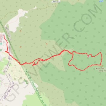
Saved_2020-03-01-19-04
- Distance: 7.6 mi
- Elevation gain: 4,882 ft
- Maximum elevation: 6,877 ft
- Elevation loss: 4,665 ft
- Minimum elevation: 2,093 ft
- Moving time: 5 h 11 m
- Moving speed: 1.5 mph
- Maximum speed: 8.2 mph
- Total time: 9 h 22 m
- Global speed: 0.8 mph
- Date: 03/01/2020
Interactive map
GPS track profile
About this GPS track
Name: Saved_2020-03-01-19-04 GPS track, route, trail
Coordinates: 35.15920 -5.25635 35.17099 -5.21643
Other GPS tracks
Click on a GPS track to view route, its statistics and profile.
Maroc en boucle depuis Tanger
Maroc > pachalik de Tanger > Tanger
Distance: 1,882.0 mi • Elevation gain: 89,413 ft • Maximum elevation: 7,549 ft
Ceuta -> Ouarzazat -> Ceuta espagne
Distance: 500.0 mi • Elevation gain: 31,946 ft • Maximum elevation: 7,188 ft
T2020-03-01-18-39
Distance: 7.6 mi • Elevation gain: 4,882 ft • Maximum elevation: 6,877 ft