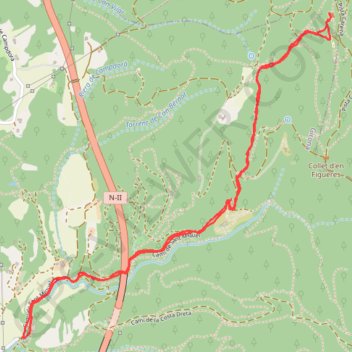
Sant Miquel (Girona)
Randonnée en aller-retour depuis Girona. #Randonnée #Pyrénées #Montagne #Nature
- Distance: 3.5 mi
- Elevation gain: 909 ft
- Maximum elevation: 1,204 ft
- Elevation loss: 912 ft
- Minimum elevation: 335 ft
- Moving time: 1 h 10 m
- Moving speed: 3.0 mph
- Maximum speed: 5.0 mph
- Total time: 1 h 12 m
- Global speed: 2.9 mph
- Date: 08/01/2011
Interactive map
GPS track profile
About this GPS track
Name: Sant Miquel (Girona) GPS track, route, trail
Start: 29, Camí de Sant Miquel, Gérone, Gironais, Gérone, 17007, Espagne (41.99260 2.84385)
End: 29, Camí de Sant Miquel, Gérone, Gironais, Gérone, Catalogne, 17007, Espagne (41.99263 2.84370)
Coordinates: 41.99260 2.84370 42.00695 2.86205
Other GPS tracks
Click on a GPS track to view route, its statistics and profile.
Southern section — European Divide Trail
France > Auvergne-Rhône-Alpes > Drôme > Valence
Distance: 1,506.1 mi • Elevation gain: 139,026 ft • Maximum elevation: 6,578 ft
1 LUCENA - MONTPELLIER
Distance: 1,842.0 mi • Elevation gain: 96,785 ft • Maximum elevation: 3,438 ft
Bardenas_Andorre_Mediterranee
Bardenas_Andorre_Mediterranee
Distance: 628.2 mi • Elevation gain: 80,394 ft • Maximum elevation: 7,264 ft
1 LUCENA - MONTPELLIER
Espagne > Andalousie > Lucena
Distance: 1,842.0 mi • Elevation gain: 96,785 ft • Maximum elevation: 3,438 ft
Stage 26: Valence to Saint-Jean-de-Fos — European Divide Trail
France > Auvergne-Rhône-Alpes > Drôme > Valence
Distance: 1,506.1 mi • Elevation gain: 139,026 ft • Maximum elevation: 6,578 ft
Barcelonne
Espagne > Haut-Ampurdan > Llançà
Barcelonne
Distance: 824.8 mi • Elevation gain: 102,241 ft • Maximum elevation: 5,692 ft
Stage 26: Valence to Saint-Jean-de-Fos — European Divide Trail
France > Auvergne-Rhône-Alpes > Drôme > Valence
Distance: 1,012.7 mi • Elevation gain: 101,184 ft • Maximum elevation: 6,578 ft
OziCE Track Log File- filtered
France > Occitanie > Pyrénées-Orientales > Banyuls-sur-Mer
OziCE Track Log File- filtered
Distance: 907.8 mi • Elevation gain: 118,281 ft • Maximum elevation: 5,715 ft
Monday Afternoon Flight
Espagne > Îles Baléares > Palma > Son Banya
Distance: 391.4 mi • Elevation gain: 87,385 ft • Maximum elevation: 8,478 ft