Trail Planner Map
- Distance: 4.2 mi
- Elevation gain: 1,106 ft
- Maximum elevation: 2,602 ft
- Elevation loss: 1,106 ft
- Minimum elevation: 1,493 ft
Interactive map
GPS track profile
About this GPS track
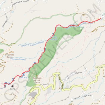
Name: Trail Planner Map GPS track, route, trail
Coordinates: 27.96578 -15.49624 27.97990 -15.47388
Other GPS tracks
Click on a GPS track to view route, its statistics and profile.
TGCC 2024 10.07.2023
Espagne > Las Palmas de Grande Canarie
Distance: 79.6 mi • Elevation gain: 23,612 ft • Maximum elevation: 5,728 ft