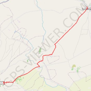
De Torremaggiore à Castelnuovo della Daunia
Randonnée depuis Torremaggiore. #Randonnée
- Distance: 13.6 mi
- Elevation gain: 1,463 ft
- Maximum elevation: 1,585 ft
- Elevation loss: 472 ft
- Minimum elevation: 384 ft
Interactive map
GPS track profile
About this GPS track
Name: De Torremaggiore à Castelnuovo della Daunia GPS track, route, trail
Start: Via Mons. Giuseppe Lariccia, Torremaggiore, Foggia, Pouilles, 71017, Italie (41.69094 15.28687)
Coordinates: 41.58007 15.12809 41.69094 15.28856
Other GPS tracks
Click on a GPS track to view route, its statistics and profile.
Percorso selezionato
Italie > Lombardie > Côme > Côme
Percorso calcolato con http://www.bicitalia.org/it/routing-gpx
Distance: 959.4 mi • Elevation gain: 58,894 ft • Maximum elevation: 3,392 ft
De Castelnuovo della Daunia à Avellaneta San Marco La Catola
Italie > Pouilles > Foggia > Castelnuovo della Daunia
Randonnée pédestre. En aller simple. #Randonnée
Distance: 11.6 mi • Elevation gain: 2,700 ft • Maximum elevation: 2,927 ft
Du monastère Santa Maria de Stignano à Torremaggiore
Italie > Pouilles > Foggia > Rignano Garganico
Randonnée entre Stignano et Torremaggiore. #Randonnée
Distance: 16.8 mi • Elevation gain: 568 ft • Maximum elevation: 886 ft