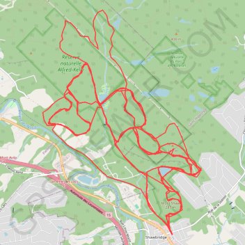
Nouvelles trails Prévost
Randonnée en aller-retour depuis Prévost. #Randonnée
- Distance: 42.9 mi
- Elevation gain: 7,844 ft
- Maximum elevation: 1,191 ft
- Elevation loss: 8,054 ft
- Minimum elevation: 515 ft
Interactive map
GPS track profile
About this GPS track
Name: Nouvelles trails Prévost GPS track, route, trail
Coordinates: 45.87302 -74.10706 45.91153 -74.06811
Other GPS tracks
Click on a GPS track to view route, its statistics and profile.