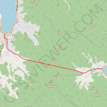
44 - Traversée Vaiare Paopao-1381948
- Distance: 3.2 mi
- Elevation gain: 213 ft
- Maximum elevation: 220 ft
- Elevation loss: 200 ft
- Minimum elevation: 3 ft
- Moving time: 1 h 44 m
- Moving speed: 1.9 mph
- Maximum speed: 1.9 mph
- Total time: 1 h 44 m
- Global speed: 1.9 mph
- Date: 06/16/2023
Interactive map
GPS track profile
About this GPS track
Name: 44 - Traversée Vaiare Paopao-1381948 GPS track, route, trail
Start: Vai’are, Moorea-Maiao, Îles du Vent, Polynésie française, 98728, France (-17.52103 -149.78164)
Coordinates: -17.52254 -149.82252 -17.50717 -149.78164
Other GPS tracks
Click on a GPS track to view route, its statistics and profile.
Moorea_traversiŠre_vaiare
France > Polynésie française > Îles du Vent > Moorea-Maiao
time=2020-08-27T18:43:13.000Z
Distance: 5.7 mi • Elevation gain: 1,516 ft • Maximum elevation: 1,158 ft
GPX • Col de Vaiare 347 m
France > Polynésie française > Îles du Vent > Moorea-Maiao > Vai’are
Wanderung auf den Col de Vaiare beim gleichnamigen Ort auf der Südseeinsel Moorea der Gesellschaftsinseln von Französisch Polynesien.
Distance: 1.6 mi • Elevation gain: 1,017 ft • Maximum elevation: 1,027 ft
2013-02-22 10:01:16
France > Polynésie française > Îles du Vent > Moorea-Maiao > Vai’are
Distance: 4.0 mi • Elevation gain: 1,070 ft • Maximum elevation: 1,073 ft