Rando - El Pino
Randonnée en boucle depuis Valencia de Alcántara. #Randonnée #Boucle
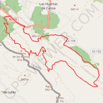
- Distance: 12.2 mi
- Elevation gain: 1,670 ft
- Maximum elevation: 2,562 ft
- Elevation loss: 1,670 ft
- Minimum elevation: 1,877 ft
- Moving time: 4 h 38 m
- Moving speed: 2.6 mph
- Maximum speed: 4.2 mph
- Total time: 7 h 8 m
- Global speed: 1.7 mph
- Date: 04/18/2011
Interactive map
GPS track profile
About this GPS track
Name: Rando - El Pino GPS track, route, trail
Coordinates: 39.31272 -7.30336 39.34710 -7.24374
Other GPS tracks
Click on a GPS track to view route, its statistics and profile.
Southern section — European Divide Trail
France > Auvergne-Rhône-Alpes > Drôme > Valence
Distance: 1,506.1 mi • Elevation gain: 139,026 ft • Maximum elevation: 6,578 ft
EuroVelo 1 (Spain)
Espagne > Andalousie > Côte occidentale > Ayamonte
Distance: 842.4 mi • Elevation gain: 47,858 ft • Maximum elevation: 4,331 ft
Eurovelo 01 Spain + Portugal
France > Nouvelle-Aquitaine > Pyrénées-Atlantiques > Hendaye
Distance: 1,930.7 mi • Elevation gain: 100,367 ft • Maximum elevation: 4,931 ft
Stage 26: Valence to Saint-Jean-de-Fos — European Divide Trail
France > Auvergne-Rhône-Alpes > Drôme > Valence
Distance: 1,506.1 mi • Elevation gain: 139,026 ft • Maximum elevation: 6,578 ft
EuroVelo 1 (Spain)
Espagne > Andalousie > Côte occidentale > Ayamonte > Pozo del Camino > Fotea
Distance: 838.7 mi • Elevation gain: 44,754 ft • Maximum elevation: 4,331 ft
LLOR2022_Final_10K_CP
Portugal > Faro > Vila Real de Santo António > Monte Gordo
Distance: 587.8 mi • Elevation gain: 66,362 ft • Maximum elevation: 3,707 ft