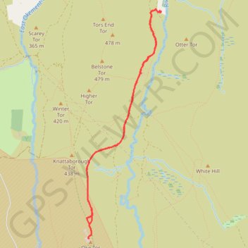
Bernard's Acre to Oke Tor
Interactive map
GPS track profile
About this GPS track
Name: Bernard's Acre to Oke Tor GPS track, route, trail
Start: Taikoo driveway, Belstone, West Devon, Devon, England, EX20 1QZ, United Kingdom (50.71691 -3.95471)
End: Taikoo driveway, Belstone, West Devon, Devon, England, EX20 1QZ, United Kingdom (50.71671 -3.95405)
Coordinates: 50.69310 -3.96617 50.71695 -3.95395
Other GPS tracks
Click on a GPS track to view route, its statistics and profile.
Tour de la petite Manche Angleterre
Royaume-Uni > Angleterre > Plymouth
Vélo. En aller simple entre Plymouth et Weymouth. #Vélo
Distance: 170.2 mi • Elevation gain: 13,432 ft • Maximum elevation: 974 ft
TT22 Jo11 J9/06 : Cheddar à Plymouth Ferry Terminal
Royaume-Uni > Angleterre > Somerset > Cheddar
Distance: 166.7 mi • Elevation gain: 13,681 ft • Maximum elevation: 1,503 ft