J4B_Roblek
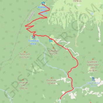
Standard approach from to to the legendary Roblek Mountain leads from Draga valley through the dense forests and alpine pastures of Mt. Begunjščica.
- Distance: 7.0 mi
- Elevation gain: 3,146 ft
- Maximum elevation: 5,358 ft
- Elevation loss: 3,146 ft
- Minimum elevation: 2,300 ft
Interactive map
GPS track profile
About this GPS track
Name: J4B_Roblek GPS track, route, trail
Start: Radovljica, 4275, Slovénie (46.39485 14.21833)
End: Radovljica, 4275, Slovénie (46.39485 14.21833)
Coordinates: 46.39485 14.20600 46.41768 14.22432
Other GPS tracks
Click on a GPS track to view route, its statistics and profile.
Tour d'Europe
France > Bretagne > Finistère > Concarneau > Landan Creis
Distance: 4,432.2 mi • Elevation gain: 146,335 ft • Maximum elevation: 7,982 ft
Eurovelo 6
France > Pays de la Loire > Loire-Atlantique > Saint-Brevin-les-Pins
Distance: 2,815.0 mi • Elevation gain: 59,196 ft • Maximum elevation: 2,808 ft
De Giromagny à Sofia
France > Bourgogne-Franche-Comté > Territoire-de-Belfort > Giromagny
Distance: 1,165.7 mi • Elevation gain: 39,724 ft • Maximum elevation: 3,458 ft
Trace Les Balkans
Italie > Frioul-Vénétie julienne > Pordenone > Versutta
Distance: 1,690.5 mi • Elevation gain: 135,249 ft • Maximum elevation: 5,902 ft
J4A_Roblek
This curcular route in the Karawanke mountain range will reward a hiker with pristine nature and beautiful views towards the Julian Alps.
Distance: 7.1 mi • Elevation gain: 3,524 ft • Maximum elevation: 5,371 ft
Euro 6
France > Pays de la Loire > Loire-Atlantique > Saint-Brevin-les-Pins
Distance: 2,634.6 mi • Elevation gain: 52,064 ft • Maximum elevation: 2,808 ft
Trace
France > Normandie > Seine-Maritime > Saint-Laurent-de-Brèvedent
Distance: 1,334.4 mi • Elevation gain: 77,890 ft • Maximum elevation: 5,308 ft