2020-09-12 陽明山東西大縱走
Recorded with Hikingbook, top-rated outdoor app from Taiwan.
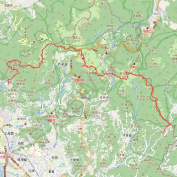
- Distance: 14.3 mi
- Elevation gain: 5,210 ft
- Maximum elevation: 3,599 ft
- Elevation loss: 5,213 ft
- Minimum elevation: 1,447 ft
- Moving time: 8 h 19 m
- Moving speed: 1.7 mph
- Maximum speed: 3.3 mph
- Total time: 10 h 58 m
- Global speed: 1.3 mph
- Date: 09/11/2020
Interactive map
GPS track profile
About this GPS track
Name: 2020-09-12 陽明山東西大縱走 GPS track, route, trail
Start: 內雙溪中上游水源涵養特別景觀區, 天溪一橋, 溪山里, District de Shilin, Taipei, 11144, Taïwan (25.13223 121.59734)
End: 廟台, 復興三路, 大屯里, Beitou, Taipei, 11248, Taïwan (25.15994 121.50067)
Coordinates: 25.13223 121.49991 25.18318 121.60273