Jan De Lichte
<p>JAN DE LICHTE.<br/>
Gewogen en te lichte bevonden.</p>
<p>Een digitale tocht door de Vlaamse Ardennen.<br/>
Hij wordt wel eens de Vlaamse Robin Hood genoemd. De lotgevallen van Jan De Lichte en zijn roversbende uit Velzeke werden dan ook literair door Hugo Claus en Louis Paul Boon vereeuwigd. Anton Cogen maakte een scenario voor een meeslepende wandeltocht doorheen het Velzeekse landschap en gebruikte daarvoor fragmenten uit de monoloog van Danny Lamarcq. De historische figuur van Jan De Lichte staat natuurlijk centraal. Maar het verhaal graaft dieper: hoe gaat onze samenleving om met mensen die niet binnen de lijntjes kleuren? En welke rol speel je in het leven om niet uit- of opgesloten te worden...</p>
- Distance: 7.1 mi
- Elevation gain: 413 ft
- Maximum elevation: 197 ft
- Elevation loss: 413 ft
- Minimum elevation: 85 ft
Interactive map
GPS track profile
About this GPS track
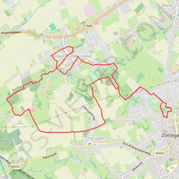
Name: Jan De Lichte GPS track, route, trail
Start: parking Bib, Meersstraat, Strijpen, Zottegem, Aalst, East Flanders, 9620, Belgium (50.87270 3.80769)
Coordinates: 50.86987 3.76602 50.88405 3.80910
Topography: Aalst topographic map
Other GPS tracks
Click on a GPS track to view route, its statistics and profile.
French Divide
France > Hauts-de-France > Nord > Bray-Dunes
Traversez la France du nord au sud sur 2200 Km de sentiers, chemins et petites routes... Magique ! Vous connaissez la mythique Great Divide ? La French Divide est elle aussi en train de devenir une grande classique des traversées en bikepacking et sans assistance !
Distance: 1,376.9 mi • Elevation gain: 110,164 ft • Maximum elevation: 4,754 ft
Tour d'Europe
France > Bretagne > Finistère > Concarneau > Landan Creis
Distance: 4,432.2 mi • Elevation gain: 146,335 ft • Maximum elevation: 7,982 ft
Kotk 2024 - Dag 2 - WZ
Belgique > Anvers > Malines > Malines
Distance: 152.6 mi • Elevation gain: 3,025 ft • Maximum elevation: 256 ft
Ronde van Vlaanderen fietsroute gele lus
Belgium > East Flanders > Oudenaarde > Oudenaarde
Distance: 63.4 mi • Elevation gain: 2,900 ft • Maximum elevation: 302 ft
TET_B-01-NW_20230301
Pays-Bas > Brabant-Septentrional > Reusel
Distance: 278.3 mi • Elevation gain: 10,413 ft • Maximum elevation: 538 ft
Via Bavay-Velzeke
Belgique > Flandre orientale > Aalst > Velsique-Ruddershove
Randonnée entre Zottegem et Bavay. #Randonnée
Distance: 49.1 mi • Elevation gain: 2,323 ft • Maximum elevation: 453 ft
Rando Paris-Amsterdam
France > Île-de-France > Paris
Vélo. En aller simple entre Paris et Amsterdam. #Vélo
Distance: 442.2 mi • Elevation gain: 14,229 ft • Maximum elevation: 810 ft
Schelderoute
Distance: 110.4 mi • Elevation gain: 1,821 ft • Maximum elevation: 56 ft
SDB-Work 32K
Belgium > East Flanders > Oudenaarde > Zwalm > Sint-Denijs-Boekel
name=SDB-Work 32K
Distance: 19.9 mi • Elevation gain: 591 ft • Maximum elevation: 279 ft
GOTOES Export
Belgium > East Flanders > Oudenaarde > Zwalm > Sint-Denijs-Boekel
Created with GOTOES STRAVA TOOLS Version 23.9
Distance: 39.7 mi • Elevation gain: 1,188 ft • Maximum elevation: 279 ft
Boire à Gand
Belgique > Bruxelles-Capitale > Anderlecht > Aa
Distance: 87.1 mi • Elevation gain: 3,251 ft • Maximum elevation: 305 ft
Zwalm-Puyenbroeck-68k
Belgium > East Flanders > Oudenaarde > Zwalm > Sint-Denijs-Boekel
name=Zwalm-Puyenbroeck-68k
Distance: 42.4 mi • Elevation gain: 814 ft • Maximum elevation: 177 ft
Mons - Hannut-Blankenberge
Belgique > Liège > Liège > Flémalle > Mons-lez-Liège
Vélo. En aller simple entre Flémalle et Blankenberge. #Vélo
Distance: 137.7 mi • Elevation gain: 2,182 ft • Maximum elevation: 653 ft
De Guirsch à Gendron (définitif) J1
Belgique > Luxembourg > Arlon > Arlon > Guirsch
Distance: 628.8 mi • Elevation gain: 40,561 ft • Maximum elevation: 2,277 ft
TET_B-01-NW_20230301
Pays-Bas > Brabant-Septentrional > Reusel
Distance: 278.3 mi • Elevation gain: 10,413 ft • Maximum elevation: 538 ft
De Guirsch à Gendron
Belgique > Luxembourg > Arlon > Arlon > Guirsch
Distance: 613.6 mi • Elevation gain: 41,873 ft • Maximum elevation: 2,277 ft
SDB-Moerzeke 46K
Belgium > East Flanders > Oudenaarde > Zwalm > Sint-Denijs-Boekel
name=SDB-Moerzeke 46K
Distance: 29.0 mi • Elevation gain: 564 ft • Maximum elevation: 230 ft
SDB-Moerzeke-60k
Belgium > East Flanders > Oudenaarde > Zwalm > Sint-Denijs-Boekel
name=SDB-Moerzeke-60k
Distance: 37.8 mi • Elevation gain: 751 ft • Maximum elevation: 197 ft
Ronde van Vlaanderen fietsroute gele lus
Belgique > Flandre orientale > Audenarde > Audenarde
Distance: 63.4 mi • Elevation gain: 2,900 ft • Maximum elevation: 302 ft
Lus Oost-Vlaanderen, Zuid
Belgique > Flandre orientale > Audenarde > Audenarde
Distance: 77.3 mi • Elevation gain: 3,031 ft • Maximum elevation: 423 ft
Kring//Belgain roads Part.6
Belgique > Bruxelles-Capitale > Bruxelles
Distance: 102.4 mi • Elevation gain: 5,013 ft • Maximum elevation: 348 ft
60km
Belgique > Flandre orientale > Audenarde > Zwalin > Boucle-Saint-Denis
name=60km
Distance: 37.3 mi • Elevation gain: 1,578 ft • Maximum elevation: 335 ft
Iedereen 1000 KOTK OVL noordlus 131km met Iben en Jana (eindresultaat deze wk 469km gefietst, 23K gelopen en 12K gewandeld)
Belgium > East Flanders > Gent > Heusden
Distance: 80.9 mi • Elevation gain: 1,900 ft • Maximum elevation: 266 ft
41K
Belgium > East Flanders > Oudenaarde > Zwalm > Sint-Denijs-Boekel
name=41K
Distance: 26.1 mi • Elevation gain: 810 ft • Maximum elevation: 164 ft
60km
Belgium > East Flanders > Oudenaarde > Zwalm > Sint-Denijs-Boekel
name=60km
Distance: 37.3 mi • Elevation gain: 1,578 ft • Maximum elevation: 335 ft