Hofaschenbach
Interactive map
GPS track profile
About this GPS track
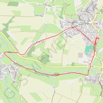
Name: Hofaschenbach GPS track, route, trail
Start: 42, Schulstraße, Hofaschenbach, Nüsttal, Landkreis Fulda, Hesse, 36167, Allemagne (50.63453 9.84749)
End: 42, Schulstraße, Hofaschenbach, Nüsttal, Landkreis Fulda, Hesse, 36167, Allemagne (50.63448 9.84761)
Coordinates: 50.62860 9.82401 50.63640 9.84767
Other GPS tracks
Click on a GPS track to view route, its statistics and profile.
Tour d'Europe
France > Bretagne > Finistère > Concarneau > Landan Creis
Distance: 4,432.2 mi • Elevation gain: 146,335 ft • Maximum elevation: 7,982 ft
Stage 14: Frederikshavn to Aars — European Divide Trail
Danemark > Jutland du Nord > Frederikshavn
Distance: 1,382.7 mi • Elevation gain: 94,114 ft • Maximum elevation: 4,557 ft
E1_Germany 3
Allemagne > Schleswig-Holstein > Schleswig-Flensburg > Oeversee
Distance: 1,179.3 mi • Elevation gain: 108,878 ft • Maximum elevation: 4,744 ft
PT23BS1 Kiel → Lörrach
Germany > Schleswig-Holstein > Kiel
Distance: 650.4 mi • Elevation gain: 30,397 ft • Maximum elevation: 2,484 ft
Marche-en-Famenne
Belgique > Luxembourg > Marche-en-Famenne > Marche-en-Famenne
<p>From Rue Dupont 46, 6900 Marche-en-Famenne, Belgium<br/> To Avenue de France, 6900 Marche-en-Famenne, Belgium</p> <p>Routing Motor - nicest</p>
Distance: 1,766.8 mi • Elevation gain: 94,672 ft • Maximum elevation: 3,537 ft
Track vom: 2020-06-27 07:26
Germany > Bavaria > Landkreis Ostallgäu > Halblech
Distance: 427.6 mi • Elevation gain: 14,131 ft • Maximum elevation: 2,989 ft
Riethoven naar Oostenrijk
Netherlands > North Brabant > Riethoven > Eind
Distance: 573.0 mi • Elevation gain: 44,715 ft • Maximum elevation: 6,224 ft
Track vom: 2020-06-13 07:00
Germany > North Rhine-Westphalia > Kreis Wesel > Schermbeck
Distance: 422.5 mi • Elevation gain: 17,392 ft • Maximum elevation: 3,022 ft