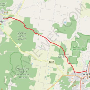
Maldon- Castlemaine Rail Trail
- Distance: 10.5 mi
- Elevation gain: 456 ft
- Maximum elevation: 1,181 ft
- Elevation loss: 705 ft
- Minimum elevation: 899 ft
- Moving time: 2 h 2 m
- Moving speed: 5.1 mph
- Maximum speed: 13.1 mph
- Total time: 2 h 2 m
- Global speed: 5.1 mph
- Date: 07/10/2023
Interactive map
GPS track profile
About this GPS track
Name: Maldon- Castlemaine Rail Trail GPS track, route, trail
Start: Hornsby Street, Maldon, Shire of Mount Alexander, Victoria, 3463, Australia (-36.99289 144.07399)
Coordinates: -37.06537 144.07399 -36.99068 144.21425
Other GPS tracks
Click on a GPS track to view route, its statistics and profile.
Goldfields Track - Castlemaine circuit
Australia > Victoria > Castlemaine
#MTB #Loop #Goldfields #Castlemaine
Distance: 10.5 mi • Elevation gain: 584 ft • Maximum elevation: 1,253 ft