Mont Rebei
Randonnée pédestre. En aller simple. #Randonnée #Lérida #Pyrénées #Montagne #Aragon #Nature
- Distance: 5.5 mi
- Elevation gain: 2,034 ft
- Maximum elevation: 2,530 ft
- Elevation loss: 2,851 ft
- Minimum elevation: 1,581 ft
- Moving time: 2 h 47 m
- Moving speed: 2.0 mph
- Maximum speed: 14.2 mph
- Total time: 3 h 29 m
- Global speed: 1.6 mph
- Date: 05/16/2015
Interactive map
GPS track profile
About this GPS track
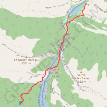
Name: Mont Rebei GPS track, route, trail
Coordinates: 42.05199 0.65534 42.09753 0.69626
Other GPS tracks
Click on a GPS track to view route, its statistics and profile.
Southern section — European Divide Trail
France > Auvergne-Rhône-Alpes > Drôme > Valence
Distance: 1,506.1 mi • Elevation gain: 139,026 ft • Maximum elevation: 6,578 ft
1 LUCENA - MONTPELLIER
Distance: 1,842.0 mi • Elevation gain: 96,785 ft • Maximum elevation: 3,438 ft
Bardenas_Andorre_Mediterranee
Bardenas_Andorre_Mediterranee
Distance: 628.2 mi • Elevation gain: 80,394 ft • Maximum elevation: 7,264 ft
1 LUCENA - MONTPELLIER
Espagne > Andalousie > Lucena
Distance: 1,842.0 mi • Elevation gain: 96,785 ft • Maximum elevation: 3,438 ft
Stage 26: Valence to Saint-Jean-de-Fos — European Divide Trail
France > Auvergne-Rhône-Alpes > Drôme > Valence
Distance: 1,506.1 mi • Elevation gain: 139,026 ft • Maximum elevation: 6,578 ft
Stage 26: Valence to Saint-Jean-de-Fos — European Divide Trail
France > Auvergne-Rhône-Alpes > Drôme > Valence
Distance: 1,012.7 mi • Elevation gain: 101,184 ft • Maximum elevation: 6,578 ft
De Villeneuve-sur-Lot à Guimarães
France > Nouvelle-Aquitaine > Lot-et-Garonne > Villeneuve-sur-Lot
Distance: 1,257.8 mi • Elevation gain: 72,575 ft • Maximum elevation: 4,393 ft