SE22-SanBartolomeDP-Avila
Total: 25.1km
- Distance: 15.6 mi
- Elevation gain: 2,090 ft
- Maximum elevation: 4,518 ft
- Elevation loss: 1,785 ft
- Minimum elevation: 2,999 ft
Interactive map
GPS track profile
About this GPS track
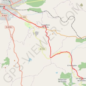
Name: SE22-SanBartolomeDP-Avila GPS track, route, trail
Coordinates: 40.54322 -4.69900 40.65624 -4.53733
Other GPS tracks
Click on a GPS track to view route, its statistics and profile.
Southern section — European Divide Trail
France > Auvergne-Rhône-Alpes > Drôme > Valence
Distance: 1,506.1 mi • Elevation gain: 139,026 ft • Maximum elevation: 6,578 ft
EuroVelo 1 (Spain)
Espagne > Andalousie > Côte occidentale > Ayamonte
Distance: 842.4 mi • Elevation gain: 47,858 ft • Maximum elevation: 4,331 ft
Eurovelo 01 Spain + Portugal
France > Nouvelle-Aquitaine > Pyrénées-Atlantiques > Hendaye
Distance: 1,930.7 mi • Elevation gain: 100,367 ft • Maximum elevation: 4,931 ft
Stage 26: Valence to Saint-Jean-de-Fos — European Divide Trail
France > Auvergne-Rhône-Alpes > Drôme > Valence
Distance: 1,506.1 mi • Elevation gain: 139,026 ft • Maximum elevation: 6,578 ft
EuroVelo 1 (Spain)
Espagne > Andalousie > Côte occidentale > Ayamonte > Pozo del Camino > Fotea
Distance: 838.7 mi • Elevation gain: 44,754 ft • Maximum elevation: 4,331 ft
SE21-Cebreros-SanBartolomeDP
Espagne > Castille-et-León > Cebreros
Total: 15.6km
Distance: 9.7 mi • Elevation gain: 1,991 ft • Maximum elevation: 4,088 ft
SE23-Avila-Gotarrendura
Espagne > Castille-et-León > Ávila
Total: 23.4km
Distance: 14.6 mi • Elevation gain: 863 ft • Maximum elevation: 3,862 ft