Canyon de la Moustique
- Distance: 2.1 mi
- Elevation gain: 502 ft
- Maximum elevation: 669 ft
- Elevation loss: 272 ft
- Minimum elevation: 197 ft
Interactive map
GPS track profile
About this GPS track
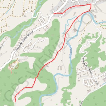
Name: Canyon de la Moustique GPS track, route, trail
End: Chemin Constant Lollia, Petit-Bourg, Basse-Terre, Guadeloupe, 97170, France (16.16188 -61.63160)
Coordinates: 16.16188 -61.63162 16.17858 -61.61816
Other GPS tracks
Click on a GPS track to view route, its statistics and profile.
45 Km
France > Guadeloupe > Lamentin > Crâne
Distance: 28.5 mi • Elevation gain: 2,736 ft • Maximum elevation: 873 ft