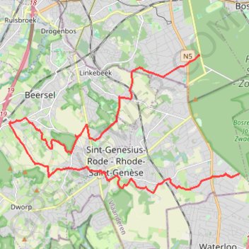
Uccle - Ukkel - Sint-Genesius-Rode - Rhode-Saint-Genèse
<p>From Chemin des Deux Montagnes - Twee Bergenweg, 1180 Uccle - Ukkel, Belgium<br/>
To Golflaan - Avenue du Golf 67, 1640 Sint-Genesius-Rode - Rhode-Saint-Genèse, Belgium</p>
<p>Routing Mountain bike - shortest</p>
- Distance: 14.7 mi
- Elevation gain: 1,027 ft
- Maximum elevation: 449 ft
- Elevation loss: 1,024 ft
- Minimum elevation: 164 ft
Interactive map
GPS track profile
About this GPS track
Name: Uccle - Ukkel - Sint-Genesius-Rode - Rhode-Saint-Genèse GPS track, route, trail
Start: Chemin des Deux Montagnes, Uccle, Bruxelles-Capitale, 1180, Belgique (50.77845 4.38896)
Coordinates: 50.73468 4.29274 50.77849 4.40879
Other GPS tracks
Click on a GPS track to view route, its statistics and profile.
Rhin par la rive gauche
Suisse > Uri > Korporation Ursern > Andermatt
Vélo. En aller simple entre Andermatt et Hoek van Holland. Suisse centrale. #Vélo #SuisseCentrale #Alpes #Montagne #Nature
Distance: 903.8 mi • Elevation gain: 22,533 ft • Maximum elevation: 6,716 ft
BBB_go_Gravel_Ohain_Braine_.gpx
Belgique > Bruxelles-Capitale > Bruxelles
Distance: 31.7 mi • Elevation gain: 1,759 ft • Maximum elevation: 456 ft
Feluy 28/4
Belgique > Bruxelles-Capitale > Bruxelles
Distance: 60.5 mi • Elevation gain: 3,527 ft • Maximum elevation: 541 ft
Eurovelo 15 - Entire Route
Pays-Bas > Hollande-Méridionale > Hoek van Holland
Distance: 903.2 mi • Elevation gain: 27,156 ft • Maximum elevation: 6,716 ft
French Divide
France > Hauts-de-France > Nord > Bray-Dunes
Traversez la France du nord au sud sur 2200 Km de sentiers, chemins et petites routes... Magique ! Vous connaissez la mythique Great Divide ? La French Divide est elle aussi en train de devenir une grande classique des traversées en bikepacking et sans assistance !
Distance: 1,376.9 mi • Elevation gain: 110,164 ft • Maximum elevation: 4,754 ft
GR655_Tracé temporaire_2020-06-10
Belgique > Bruxelles-Capitale > Bruxelles
Distance: 90.4 mi • Elevation gain: 6,949 ft • Maximum elevation: 656 ft
Tour d'Europe
France > Bretagne > Finistère > Concarneau > Landan Creis
Distance: 4,432.2 mi • Elevation gain: 146,335 ft • Maximum elevation: 7,982 ft
Rhin par la rive gauche
Suisse > Uri > Korporation Ursern > Andermatt
Distance: 903.6 mi • Elevation gain: 20,518 ft • Maximum elevation: 6,726 ft
Gravel 19 - 50 km
Belgique > Brabant flamand > Louvain > Tervuren
Distance: 32.3 mi • Elevation gain: 1,906 ft • Maximum elevation: 463 ft
Hallebos
Belgique > Bruxelles-Capitale > Auderghem
<p>From Avenue des Bécassines - Watersneppenlaan 35, 1160 Auderghem - Oudergem, Belgium<br/> To Chemin du Fer à cheval - Hoefijzerweg, 1180 Uccle - Ukkel, Belgium</p> <p>Routing Mountain bike - shortest</p>
Distance: 24.4 mi • Elevation gain: 1,703 ft • Maximum elevation: 456 ft
Arquennes
Belgique > Bruxelles-Capitale > Auderghem
<p>From Avenue des Martinets - Steenzwaluwenlaan 25, 1160 Auderghem - Oudergem, Belgium<br/> To Avenue Delleur - Delleurlaan 13, 1170 Boitsfort - Bosvoorde, Belgium</p> <p>Routing Race cycling - shortest</p>
Distance: 61.6 mi • Elevation gain: 3,268 ft • Maximum elevation: 528 ft
TET_B-01-NW_20230301
Pays-Bas > Brabant-Septentrional > Reusel
Distance: 278.3 mi • Elevation gain: 10,413 ft • Maximum elevation: 538 ft
Bois de Halle
Belgique > Bruxelles-Capitale > Bruxelles
Distance: 23.8 mi • Elevation gain: 1,939 ft • Maximum elevation: 430 ft
Chateau-Fort de Feluy
Belgique > Bruxelles-Capitale > Bruxelles
Distance: 59.5 mi • Elevation gain: 3,612 ft • Maximum elevation: 541 ft
Josaphat - Tour de Bruxelles - 85km - 779m
Belgique > Bruxelles-Capitale > Schaerbeek
Distance: 52.8 mi • Elevation gain: 2,638 ft • Maximum elevation: 420 ft
Autumn in BW - 95km - 1000D+
Belgique > Bruxelles-Capitale > Bruxelles
Distance: 58.8 mi • Elevation gain: 3,386 ft • Maximum elevation: 538 ft
Eurovelo 15 - Strasbourg Rotterdam
France > Grand Est > Bas-Rhin > Strasbourg
comment ...
Distance: 554.1 mi • Elevation gain: 7,021 ft • Maximum elevation: 479 ft
Eurovéloroute-15-Route-du-Rhin
Suisse > Uri > Korporation Ursern > Andermatt
Distance: 931.4 mi • Elevation gain: 22,854 ft • Maximum elevation: 6,713 ft
Eurovelo 15 - Entire Route
Pays-Bas > Hollande-Méridionale > Hoek van Holland
Distance: 903.5 mi • Elevation gain: 25,433 ft • Maximum elevation: 6,726 ft
Rando Paris-Amsterdam
France > Île-de-France > Paris
Vélo. En aller simple entre Paris et Amsterdam. #Vélo
Distance: 442.2 mi • Elevation gain: 14,229 ft • Maximum elevation: 810 ft
Schelderoute
Distance: 110.4 mi • Elevation gain: 1,821 ft • Maximum elevation: 56 ft
Gravel Buizingen
Belgique > Bruxelles-Capitale > Bruxelles
Distance: 27.2 mi • Elevation gain: 1,601 ft • Maximum elevation: 436 ft
Lasne
Belgique > Bruxelles-Capitale > Auderghem
<p>From Avenue Isidore Geyskens - Isidore Geyskenslaan 120, 1160 Auderghem - Oudergem, Belgium<br/> To Avenue Isidore Geyskens - Isidore Geyskenslaan 120, 1160 Auderghem - Oudergem, Belgium</p> <p>Routing Mountain bike - shortest</p>
Distance: 39.2 mi • Elevation gain: 2,625 ft • Maximum elevation: 469 ft
GR655_Parcours-Complet_T_2023-05-09
Belgique > Bruxelles-Capitale > Bruxelles
GR655_Parcours-Complet_T_2023-05-09
Distance: 92.8 mi • Elevation gain: 7,283 ft • Maximum elevation: 656 ft
Cardinal Mercier A 4/2
Belgique > Bruxelles-Capitale > Bruxelles
Distance: 47.1 mi • Elevation gain: 3,051 ft • Maximum elevation: 495 ft
Bercuit A
Belgique > Bruxelles-Capitale > Bruxelles
Distance: 54.6 mi • Elevation gain: 3,150 ft • Maximum elevation: 466 ft
Enghien
Belgique > Bruxelles-Capitale > Auderghem
<p>From Avenue du Parc de Woluwe - Park van Woluwelaan 42, 1160 Auderghem - Oudergem, Belgium<br/> To Avenue du Parc de Woluwe - Park van Woluwelaan 42, 1160 Auderghem - Oudergem, Belgium</p> <p>Routing Race cycling - shortest</p>
Distance: 60.0 mi • Elevation gain: 3,110 ft • Maximum elevation: 495 ft
Point du jour 29/10
Belgique > Bruxelles-Capitale > Bruxelles
Distance: 59.1 mi • Elevation gain: 3,432 ft • Maximum elevation: 518 ft
Gravel 19 - 50 km
Belgique > Brabant flamand > Louvain > Tervuren
Distance: 32.3 mi • Elevation gain: 1,719 ft • Maximum elevation: 463 ft
🪨 BBB GRAVEL (15) (S) 56km 770D+ Lasne
Belgique > Bruxelles-Capitale > Bruxelles
Route by James Watson The villages around Lasne may be full of tennis courts, swimming pools and stables, but its the fantastic off-road riding that we think is the real highlight. This ride is a long one, with some more technical sections making it more challenging but also rewarding.
Distance: 34.7 mi • Elevation gain: 2,484 ft • Maximum elevation: 472 ft
BHCC 2022 #8 Bercuit-Chaumont Gistoux (Short) (E) 67km 700D+
Belgique > Bruxelles-Capitale > Bruxelles
With just 3 rounds to go, including the 'live' finale on Rue du Mystere, the action in the Brussels Hill Climb Challenge is hotting up. Last week we saw a fantastic 75 BBB members register a time up Bruyere du Wez, with congratulations to Dominique Rongvaux on becoming the new KOM on the climb after smashing the 8 year old record.…
Distance: 41.6 mi • Elevation gain: 2,671 ft • Maximum elevation: 433 ft
Bercuit B tourer
Belgique > Bruxelles-Capitale > Bruxelles
Distance: 37.7 mi • Elevation gain: 2,569 ft • Maximum elevation: 440 ft
🪨 BBB GRAVEL (8) (SE) 52km 680D+ E411 Tombeek (gravel variation)
Belgique > Bruxelles-Capitale > Bruxelles
(E411) Tombeek We've named this week's gravel route with a nod to the cobbled classic E3 Harelbeek, due to it also following the direction of a motorway, but the ride is very much in Brabantse Pijl country. With the outward and return routes often close to each other, there are also plenty of options to shorten the ride and add your…
Distance: 32.4 mi • Elevation gain: 2,149 ft • Maximum elevation: 440 ft
Ohain
Belgique > Bruxelles-Capitale > Auderghem
<p>From Avenue des Mésanges - Mezenlaan 11, 1160 Auderghem - Oudergem, Belgium<br/> To Drève Pittoresque - Schilderachtige Dreef 1, 1180 Uccle - Ukkel, Belgium</p> <p>Routing Race cycling - shortest</p>
Distance: 38.5 mi • Elevation gain: 2,231 ft • Maximum elevation: 479 ft
Waterloo
Belgique > Bruxelles-Capitale > Bruxelles
Distance: 31.6 mi • Elevation gain: 1,814 ft • Maximum elevation: 463 ft
Brabant W B 22/10
Belgique > Bruxelles-Capitale > Bruxelles
Distance: 48.1 mi • Elevation gain: 3,153 ft • Maximum elevation: 466 ft
Emile Daems Classic (long)
Belgique > Bruxelles-Capitale > Bruxelles
Distance: 59.0 mi • Elevation gain: 3,005 ft • Maximum elevation: 384 ft
GR655_Parcours-Complet_T_2023-05-09
Belgique > Bruxelles-Capitale > Bruxelles
GR655_Parcours-Complet_T_2023-05-09
Distance: 92.8 mi • Elevation gain: 7,283 ft • Maximum elevation: 656 ft
BBB Gravel Soignes 56km 700D+
Belgique > Bruxelles-Capitale > Bruxelles
Distance: 34.6 mi • Elevation gain: 2,152 ft • Maximum elevation: 463 ft
BBB Seneffe A
Belgique > Bruxelles-Capitale > Bruxelles
Distance: 60.9 mi • Elevation gain: 3,022 ft • Maximum elevation: 545 ft
Strada Bianchi - Huldenburg
Belgique > Bruxelles-Capitale > Bruxelles
Distance: 27.8 mi • Elevation gain: 1,722 ft • Maximum elevation: 427 ft
BBBgoGravel - LLN
Belgique > Bruxelles-Capitale > Bruxelles
Distance: 35.0 mi • Elevation gain: 2,589 ft • Maximum elevation: 456 ft
REV Ride (long)
Belgique > Bruxelles-Capitale > Bruxelles
Distance: 60.4 mi • Elevation gain: 2,326 ft • Maximum elevation: 377 ft
Eurovelo 15 - Strasbourg Rotterdam
France > Grand Est > Bas-Rhin > Strasbourg
Distance: 554.1 mi • Elevation gain: 6,903 ft • Maximum elevation: 479 ft
Eurovelo 15 - Entire Route
Pays-Bas > Hollande-Méridionale > Hoek van Holland
Distance: 903.5 mi • Elevation gain: 25,433 ft • Maximum elevation: 6,726 ft