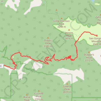
San Gorgonio Mountain (Vivian Creek Trail)
Hike to the San Gorgonio Mountain by the Vivian Creek Trail in the San Gorgonio Wilderness. #Hike #Mountain #Nature #Forest #Wilderness
- Distance: 8.9 mi
- Elevation gain: 5,479 ft
- Maximum elevation: 11,490 ft
- Elevation loss: 95 ft
- Minimum elevation: 6,106 ft
Interactive map
GPS track profile
About this GPS track
Name: San Gorgonio Mountain (Vivian Creek Trail) GPS track, route, trail
Start: Vivian Trailhead, San Bernardino County, California, United States (34.08172 -116.89102)
End: San Gorgonio Mountain Trail, San Bernardino County, California, United States (34.09927 -116.82486)
Coordinates: 34.07951 -116.89102 34.10144 -116.82483
Topography: San Bernardino County topographic map
Other GPS tracks
Click on a GPS track to view route, its statistics and profile.
Dobbs Cabin
United States > California > San Bernardino County > Forest Falls
Hike to Dobbs Cabin Camp by the Momyer Creek Trail, the Fals Creek Trail and the Dobbs Cabin Spur in the San Gorgonio Wilderness, the Sand to Snow National Monument and the San Bernardino National Forest. #Hike #Mountain #Forest #Nature #Wilderness
Distance: 5.6 mi • Elevation gain: 2,792 ft • Maximum elevation: 7,513 ft
San Gorgonio Mountain (South Fork Trail)
United States > California > San Bernardino County
Hike to San Gorgonio Mountain via South Fork Trail, Poopout Hill, Dollar Lake Saddle, San Bernardino Peak Trail and San Gorgonio Mountain Trail in the Sand to Snow National Monument and the San Gorgonio Wilderness. #Hike #Mountain #Nature #Forest #Wilderness
Distance: 9.5 mi • Elevation gain: 4,675 ft • Maximum elevation: 11,490 ft