Etape 7 Alaejos - Garda
- Distance: 149.0 mi
- Elevation gain: 7,260 ft
- Maximum elevation: 2,907 ft
- Elevation loss: 8,035 ft
- Minimum elevation: 1,385 ft
Interactive map
GPS track profile
About this GPS track
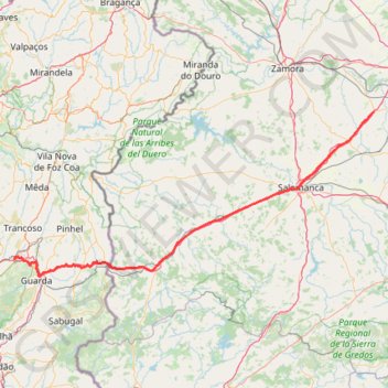
Name: Etape 7 Alaejos - Garda GPS track, route, trail
Coordinates: 40.55470 -7.39489 41.30637 -5.21868
Other GPS tracks
Click on a GPS track to view route, its statistics and profile.
Southern section — European Divide Trail
France > Auvergne-Rhône-Alpes > Drôme > Valence
Distance: 1,506.1 mi • Elevation gain: 139,026 ft • Maximum elevation: 6,578 ft
EuroVelo 1 (Spain)
Espagne > Andalousie > Côte occidentale > Ayamonte
Distance: 842.4 mi • Elevation gain: 47,858 ft • Maximum elevation: 4,331 ft
T-n222.a.melhor.estrada.do.mundo_andar.de.coiso
Portugal > Porto > Vila Nova de Gaia
Distance: 141.5 mi • Elevation gain: 17,858 ft • Maximum elevation: 2,398 ft
Eurovelo 01 Spain + Portugal
France > Nouvelle-Aquitaine > Pyrénées-Atlantiques > Hendaye
Distance: 1,930.7 mi • Elevation gain: 100,367 ft • Maximum elevation: 4,931 ft
Volta Nortenha - Maia / Valença / Gerês / Bragança / Mogadou...
Distance: 554.7 mi • Elevation gain: 86,745 ft • Maximum elevation: 4,888 ft
Stage 26: Valence to Saint-Jean-de-Fos — European Divide Trail
France > Auvergne-Rhône-Alpes > Drôme > Valence
Distance: 1,506.1 mi • Elevation gain: 139,026 ft • Maximum elevation: 6,578 ft
EuroVelo 1 (Spain)
Espagne > Andalousie > Côte occidentale > Ayamonte > Pozo del Camino > Fotea
Distance: 838.7 mi • Elevation gain: 44,754 ft • Maximum elevation: 4,331 ft
LLOR2021_ET01
Portugal > Vila Real > Montalegre
Distance: 202.7 mi • Elevation gain: 27,959 ft • Maximum elevation: 4,075 ft
Etape 8 Guarda - Soutocico
Portugal > Guarda > Celorico da Beira
Distance: 129.1 mi • Elevation gain: 10,171 ft • Maximum elevation: 1,975 ft
Braga para Miradouro Do Ujo
Distance: 213.2 mi • Elevation gain: 24,567 ft • Maximum elevation: 3,419 ft
LLOR2022_Final_10K_CP
Portugal > Faro > Vila Real de Santo António > Monte Gordo
Distance: 587.8 mi • Elevation gain: 66,362 ft • Maximum elevation: 3,707 ft
Etape 6 Briviesca - Alaejos
Espagne > Castille-et-León > Briviesca
Distance: 153.7 mi • Elevation gain: 7,182 ft • Maximum elevation: 3,202 ft